At a glance
Sourced facts only. Distances and services change — confirm before you travel.
- Population
- 2,079 people (UCL315020, 2021 Census)Also 2,952 people at SAL30621 (SAL). Do not mix UCL and SAL in one headcount.
- Local government
- Isaac Regional Council
- Nearest regional city
- Mackay 290 km / 3.5 hours on Isaac visitor material used on the Clermont weather page
- Nearest fuel
- Confirm in the service town named under nearest regional city; this guide does not list bowser brands.
- Nearest hospital or clinic
- Confirm with Queensland Health — do not invent a clinic name.
- Mobile coverage
- Check Telstra and Optus coverage maps before travel; do not assume a signal on floodways, parks or unsealed approaches.
- Best time to visit
- May–September on Clermont Airport (035124) cooler mean maxima (July 23.5 °C; January 34.3 °C). QLDTraffic after rain.
Climate
Monthly means from the Bureau of Meteorology station Clermont Airport (035124). This is not a forecast. Commenced 2010. Elevation 270 m. Status: Open. Annual mean rainfall 566.5 mm. Clermont Airport is the table used on the Clermont weather page. Clermont Post Office (035019) is closed — do not blend.
| Month | Mean max (°C) | Mean min (°C) | Rainfall (mm) |
|---|---|---|---|
| Jan | 34.3 | 21.7 | 111.3 |
| Feb | 33.5 | 21.2 | 73.9 |
| Mar | 32.3 | 20.0 | 101.9 |
| Apr | 29.5 | 15.3 | 26.6 |
| May | 26.0 | 10.6 | 21.2 |
| Jun | 23.6 | 7.7 | 21.0 |
| Jul | 23.5 | 6.4 | 28.3 |
| Aug | 26.0 | 7.1 | 15.9 |
| Sep | 29.2 | 11.5 | 20.2 |
| Oct | 32.5 | 16.1 | 43.6 |
| Nov | 33.9 | 19.1 | 71.6 |
| Dec | 34.4 | 20.8 | 70.6 |
Clermont in pictures
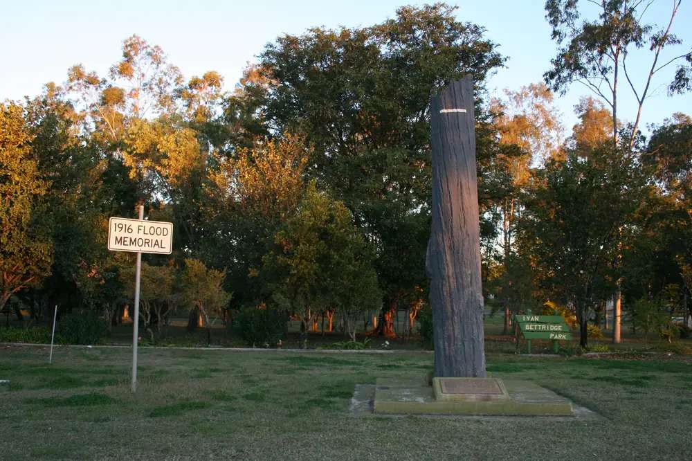
Clermont's flood memorialPhoto: www.gondwananet.com · CC BY-SA 3.0 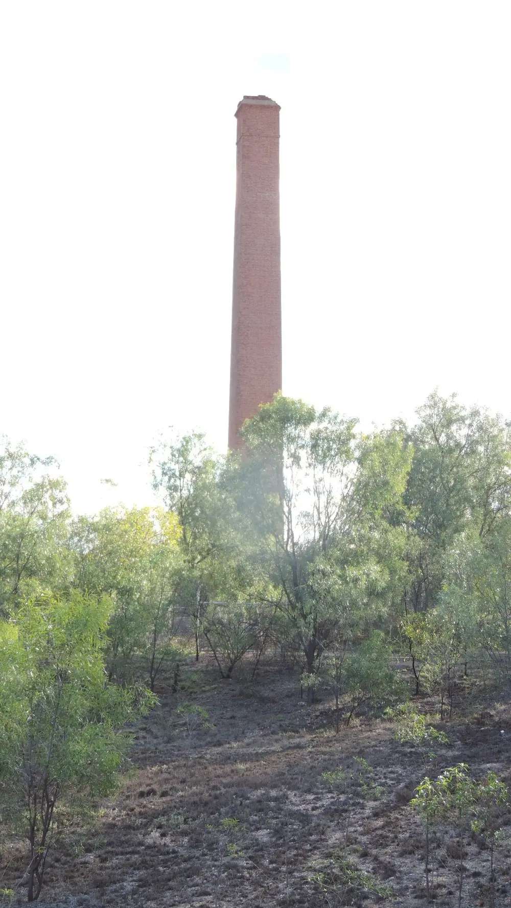
The Copperfield chimney in ClermontPhoto: Kerry Raymond · CC BY 4.0 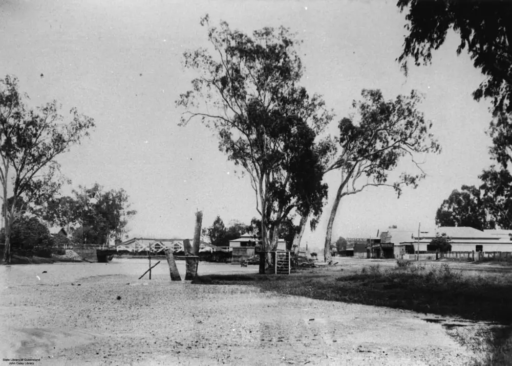
Drummond Street in ClermontPhoto: Item is held by John Oxley Library, State Library of Queensland. · Public domain 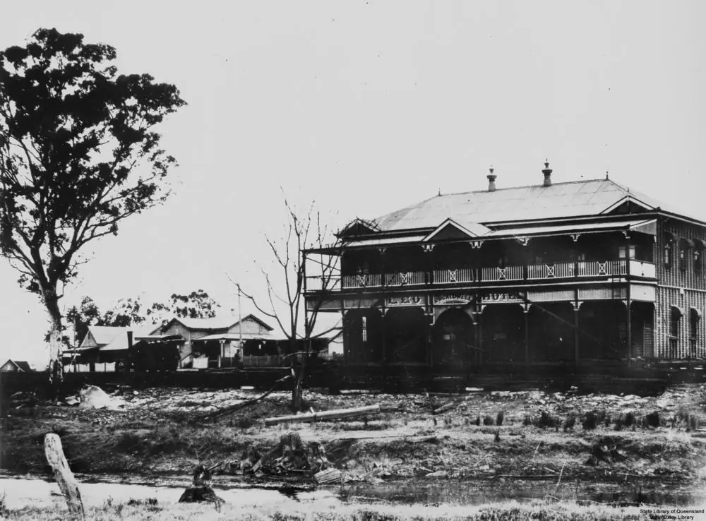
The Leo Hotel being moved after Clermont's floodPhoto: Item is held by John Oxley Library, State Library of Queensland. · Public domain
Clermont sits on the Gregory Highway in the Isaac Region of central Queensland, a sealed inland town on the Capricorn and Burnett hub. Mackay Isaac’s road table puts Mackay 290 km away (about 3.5 hours) via the Peak Downs Highway. Isaac Regional Council calls Clermont one of the most historic towns in northern Australia and the first inland settlement in the tropics — gold, copper, timber, shearers and, later, coal. This is Peak Downs country, not Channel Country. Use Clermont to walk Hoods Lagoon, see Copperfield from the roadside, camp at Theresa Creek Dam, and fossick only where Queensland Government general permission areas and a current licence allow.
Nearby on this site: Emerald and Sapphire, Queensland Gemfields. Do not treat a Gemfields camping permit as a Clermont gold-camp permit; camping is not permitted on Clermont GPAs.
Where it is, and how far
Distances below are from Mackay Isaac, Isaac Regional Council or the Queensland Government. They are driving kilometres or official “about” times, not a guarantee in mine-shift traffic or after storms.
| Place | Distance (official wording) |
|---|---|
| Mackay | 290 km, about 3.5 hours (Mackay Isaac road table); 289 km on the 2026 visitor-guide distance panel |
| Copperfield | About 4 km south (Isaac Clermont town page) |
| Clermont Historical Centre | 2 km north along the Gregory Highway (Isaac town page) |
| Theresa Creek Dam | 22 km southwest (Isaac camping page) |
| Hoods Lagoon circuit | Approximately 1.8 km (Isaac town page) |
If you are continuing south toward Emerald and the Gemfields, use QLDTraffic rather than an invented Clermont–Emerald kilometre count. North-west, Laglan Road is the Queensland Government access note for most gold GPAs. South, McDonald Flat Road serves one GPA. The Peak Downs Highway is the scenic drive Isaac names for Peak Range views toward Moranbah and Dysart.
Facts at a glance
The Australian Bureau of Statistics counted 2,079 people in the Clermont urban centre at the 2021 Census (Urban Centres and Localities code UCL315020). Median age was 34. The sex split was 50.0% male and 50.0% female. That UCL figure is the one to use for the town. The suburbs-and-localities geography (SAL30621) counted 2,952 people; do not mix the two. Read the ABS QuickStats page for Clermont UCL.
Climate figures come from Clermont Airport (035124), which commenced in 2010. Location 22.78°S, 147.62°E, elevation 270 m. Status: open. Annual mean rainfall 566.5 mm over 15 years (2010–2026) on the summary table. Hottest month by mean maximum: December 34.4 °C (January is 34.3 °C). Coolest: July 23.5 °C. Wettest month on that table: January 111.3 mm. Full columns: BOM Clermont Airport. Our Clermont weather page explains what those averages mean for a visit.
Clermont is large enough for fuel, groceries and a museum desk, which is why caravanners treat it as a practical overnight on the Gregory and Peak Downs highways. It is not a 12,000-person Downs centre. Plan for museum hours that are Wednesday–Saturday, not seven days.
Traditional Owners
The Clermont Museum page on Isaac Regional Council opens with “Welcome to Wangan and Jagalingou country.” The Mackay Isaac 2026 visitor guide maps Clermont on Wangan and Jagalingou Country. This guide follows that council and regional-tourism wording for the townsite rather than importing a different nation’s name from a neighbouring shire. Read Isaac’s museum page and confirm plaque wording at the visitor centre on (07) 4983 3311.
History
Isaac’s Clermont town page is the copper and flood story this guide uses.
Copperfield. About 4 km south, a high wall of copper ore was discovered in 1862 on the town page (the May 2026 Isaac visitor guide dates the discovery to 1861 and names Jack Mollard and a 10-metre wall). Queensland’s first copper mine opened; the town page says the mine continued until the 1880s when the best ore was mined out, and that Copperfield was once a town of 2,000 people. The visitor guide dates the Peak Downs Copper Mining Company’s first smelt to late 1864 and final closure to 1907. What remains is a brick chimney, the old general store and Copperfield Cemetery on Rubyvale Road. Isaac’s facility pages state there is no public access to the chimney for safety, and no public access to the interior of the store. Look from the road. Do not climb.
Blair Athol coal. Coal was first discovered in 1864 at Blair Athol Station while sinking a well. Isaac records export by rail from 1890, a branch line completed in 1909, open-cut mining from 1936, and Blair Athol Coal ceased operations in 2012.
1916 flood. Isaac calls it Clermont’s most iconic event: the flood washed away the central business district and claimed at least 65 lives, still described on that page as Australia’s second-worst flood in terms of loss of life. The flood marker is on the corner of Capricorn and Drummond Streets. The Piano in the Tree in Capricorn Street is a replica; Isaac says three pianos were found in trees after the flood. The mass grave is in Clermont Cemetery. Rose Harris Park on Capella Street is named for Rose Harris and her father, who saved five lives; Isaac says she later ran a saddlery and was believed to be the only female saddler in Australia at the time.
Gold. Isaac’s town-page fun fact estimates more than 7,380 kg of gold recovered on the Clermont goldfields between 1861 and 1901. The Queensland Government dates the alluvial discovery in gullies south of Clermont to 1861. Modern fossicking is on twelve general permission areas, not on private property or live claims.
Things to do
Start at the Clermont Visitor Information Centre inside the Clermont Historical Centre, 17217 Gregory Highway, 2 km north of town. Phone (07) 4983 3311. Mackay Isaac lists Wednesday–Saturday 9am–3pm. Isaac’s museum page lists free entry, more than 8,000 artefacts, the Aveling and Porter steam engine used after the 1916 flood, shearing-shed and lodge buildings. Confirm hours before a public holiday. Isaac has used seasonal closures; do not assume seven-day opening.
Hoods Lagoon and Centenary Park — birds, boardwalk, 1.8 km circuit, 1916 flood memorials, war memorial, Billy Sing memorial, Mary MacKillop grotto and an Indigenous heritage site on the town page.
Copperfield — roadside chimney, store and cemetery, 4 km south. No interior access.
Theresa Creek Dam — 22 km southwest, built 1983: swimming, canoeing, water skiing, fishing (permits required except redclaw, possession limit 40), two sealed-approach boat ramps, kiosk, camping. Fees apply.
Gold fossicking — twelve GPAs; licence required; camping not permitted; hand tools including metal detectors; no generators; maps and special conditions from the Queensland Government central gold page.
Peak Range National Park — scenic drive on the Peak Downs Highway. The Isaac visitor guide states no motorised vehicle access, facilities or defined walking tracks inside the park, and fires and camping are prohibited. Self-reliant only. Check Queensland Parks before you leave the highway.
A fuller day order is on things to do in Clermont.
Where to stay
Isaac and Queensland Government copy support town accommodation in Clermont and camping at Theresa Creek Dam. GPA fossicking land is not a camp. This page does not publish a ranked motel list, prices or ratings.
- How to choose a type of stay: Clermont accommodation
- Dam camping and van notes: Clermont caravan parks
- Empty listings and operator enquiries: feature your business
Book ahead for school holidays and the agricultural show (Isaac visitor guide names late May). If Clermont is full, Emerald is the next large guide on this site — confirm the road on QLDTraffic.
Caravan and camping
Clermont works as a van overnight because the Gregory and Peak Downs highways are sealed, the town has supplies, and Theresa Creek Dam is a 22 km sealed-approach camp with showers, toilets and a dump point on the council camping page. Camping is not permitted on the gold GPAs. Read Clermont caravan parks and caravanning in the outback.
Fuel and services
Clermont is a 2,079-person urban centre. Fuel, groceries and food sit in town. This guide does not list brand names or hours that go stale. Fill up here if you are heading toward Laglan Road GPAs or the long Gregory Development Road north; the Isaac visitor guide notes Belyando Crossing as the only service point on the 368 km between Clermont and Charters Towers besides a rest stop at Cape River. Carry water. Mobile coverage can drop on GPA tracks.
Road access
Sealed highways:
- Gregory Highway — north–south through Clermont toward Emerald country in the south and Charters Towers country in the north.
- Peak Downs Highway — east toward Moranbah and Mackay (290 km, 3.5 hours on Mackay Isaac).
These are freight and mine roads. Expect road trains and shift traffic. After storms, creeks on Laglan Road and McDonald Flat Road can close GPA access even when town stays dry. Check QLDTraffic and call 13 19 40. Do not drive around closed signs. See wet season and road closures and kangaroos and driving safety.
Nearby parks and towns
Sites named in Isaac or Queensland Government material:
- Clermont Historical Centre / Museum, 17217 Gregory Highway
- Hoods Lagoon and Centenary Park (1.8 km circuit)
- 1916 flood marker and Piano in the Tree
- Rose Harris Park, Capella Street
- Copperfield chimney, store and cemetery (roadside only)
- Theresa Creek Dam, 22 km southwest
- Twelve gold general permission areas (licence required; no camping)
- Peak Range National Park (highway views; no camping in the park on Isaac visitor-guide wording)
Towns on this site:
- Emerald — Central Highlands service town, Lake Maraboon
- Sapphire, Queensland Gemfields — sapphire fossicking west of Emerald; different licence maps
- Duaringa — Capricorn Highway rest town east of Emerald
Capella, Moranbah and Dysart appear in Isaac copy but do not have town guides here.
When to go, and how long
For comfortable walking, autumn and spring sit between December’s mean maximum (34.4 °C at Clermont Airport) and July (23.5 °C). Summer is the wetter half of the year (January 111.3 mm). See Clermont weather and best time to visit the outback.
One night is enough for the lagoon and museum if you hit Wednesday–Saturday hours. Two nights lets you add Copperfield and Theresa Creek Dam. Three nights only if you have printed GPA maps, a fossicking licence, and QLDTraffic still supports Laglan Road.
Operators who want a checked listing on this town page can use feature your business. Until then the listings slot stays empty on purpose.
Plan this trip
Tell us the dates, who you are travelling with and where you need help. We reply with planning notes for Clermont — we are not a booking agent.
Events and road-conditions newsletter
Occasional notes on outback festivals, race days and official road-condition sources — not a daily blast. We use these details only to send the newsletter.
Queensland · Isaac Region
Clermont accommodation
Where to stay in Clermont: town hotels and motels, caravan parks, and Theresa Creek Dam camping 22 km southwest. Official Isaac directories, not a fake hotel round-up. No camping on gold GPAs.
Read · 4 min
Queensland · Isaac Region
Clermont caravan parks
Caravan parks and camping in Clermont: township parks as a category plus Theresa Creek Dam 22 km southwest. Gold GPAs are not camps. Official Isaac and Queensland Government rules only.
Read · 4 min
Queensland · Isaac Region
Clermont weather
Clermont climate from Bureau of Meteorology Clermont Airport (035124): December mean maximum 34.4 °C, July 23.5 °C, annual rainfall 566.5 mm. Full monthly table on BOM.
Read · 5 min
Queensland · Isaac Region
Things to do in Clermont
Things to do in Clermont: Historical Centre, Hoods Lagoon, 1916 flood memorials, Copperfield chimney, Theresa Creek Dam and Queensland Government gold general permission areas.
Read · 5 min
Frequently asked questions
How far is Clermont from Mackay?
Mackay Isaac’s travel-by-road table puts Clermont 290 km from Mackay, about 3.5 hours, via the Peak Downs Highway. The 2026 visitor guide also lists 289 km to Mackay.
What is Clermont’s population?
2,079 people at the 2021 Census for the Clermont urban centre (UCL315020). The suburb/locality figure is larger (SAL30621, 2,952) and is not the town count.
Do I need a licence to fossick for gold at Clermont?
Yes. The Queensland Government requires a fossicking licence on the twelve general permission areas around Clermont. Hand tools (including metal detectors) only. Camping is not permitted on those GPAs. Stay off mining claims and leases without the holder’s permission.
When is the best weather in Clermont?
Bureau of Meteorology means for Clermont Airport (035124) show the hottest month by mean maximum in December (34.4 °C) and the coolest in July (23.5 °C). Annual mean rainfall is 566.5 mm over 15 years of record, wetter in summer.
Where is the Clermont visitor centre?
Clermont Visitor Information Centre is inside the Clermont Historical Centre / Museum at 17217 Gregory Highway. Phone (07) 4983 3311. Mackay Isaac lists Wednesday–Saturday 9am–3pm. Confirm before you arrive.
Can I camp at Theresa Creek Dam?
Yes. Isaac Regional Council lists the dam 22 km southwest of Clermont with camping, showers, toilets, a dump point and a kiosk. Camping fees apply. Confirm current fees and rules on the council camping page before you tow.
Sources and further reading
Facts on this page were checked against these primary and official sources. Conditions change — confirm before you travel or buy.
- Clermont 2021 Census QuickStats (SAL30621) — Australian Bureau of Statistics
- Clermont 2021 Census QuickStats (UCL315020) — Australian Bureau of Statistics
- Climate statistics for Clermont Airport (035124) — Bureau of Meteorology
- Isaac Regional Council — Clermont — Isaac Regional Council
- Clermont Museum — Isaac Regional Council
- Central gold district fossicking — Queensland Government
- Theresa Creek Dam camping — Isaac Regional Council
- Mackay Isaac — travel by road — Mackay Isaac
- QLDTraffic — Queensland Government