At a glance
Sourced facts only. Distances and services change — confirm before you travel.
- Local government
- Boulia Shire
- Nearest regional city
- Use kilometres printed on Boulia Shire / Outback Queensland pages used here. Do not invent a Mount Isa–Urandangi total those pages omit.
- Mobile coverage
- Check Telstra and Optus coverage maps before travel; do not assume a signal.
- Best time to visit
- May–September on Urandangi cooler mean maxima; unsealed roads close after rain
Climate
Monthly means from the Bureau of Meteorology station Urandangi (037043). This is not a forecast. BOM climate-averages summary lists status Open with latest available data 11 September 2012. Township table, not Urandangi Aerodrome (037058). Do not blend. Commenced 1891. Elevation 174 m.
| Month | Mean max (°C) | Mean min (°C) | Rainfall (mm) |
|---|---|---|---|
| Jan | 38.5 | 24.0 | 62.8 |
| Feb | 37.1 | 23.3 | 66.3 |
| Mar | 35.6 | 21.0 | 42.9 |
| Apr | 32.4 | 16.7 | 13.1 |
| May | 27.5 | 12.0 | 12.2 |
| Jun | 24.3 | 8.3 | 9.3 |
| Jul | 24.0 | 7.0 | 10.2 |
| Aug | 26.8 | 8.8 | 4.4 |
| Sep | 31.3 | 13.0 | 6.3 |
| Oct | 35.1 | 17.5 | 14.3 |
| Nov | 37.4 | 20.5 | 22.2 |
| Dec | 38.8 | 22.7 | 38.9 |
Urandangie (Urandangi) in pictures
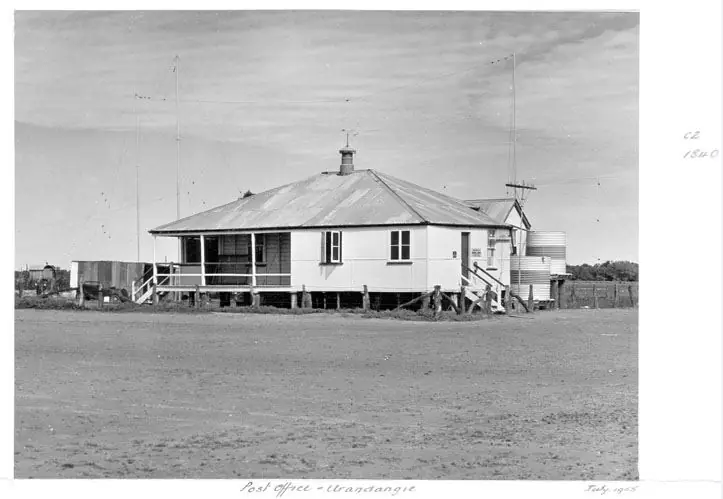
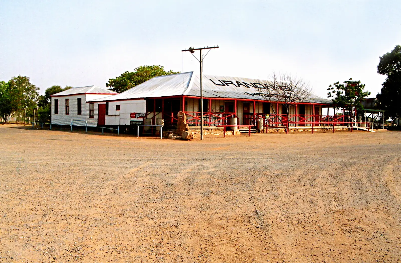
The Urandangi post officePhoto: Queensland State Archives · PDM-owner 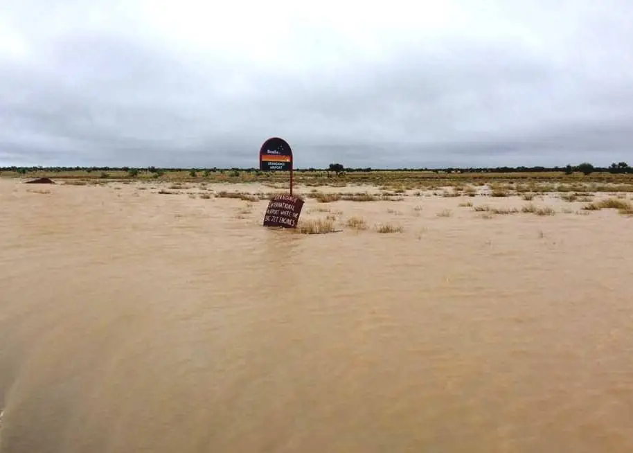
Urandangi airstrip flooded by the Georgina RiverPhoto: John Robert McPherson · CC BY-SA 4.0
Urandangi is a Boulia Shire town on the Georgina River, on the Mount Isa–Boulia fringe and the Queensland–Northern Territory border country. Boulia Shire Council’s page is the source for that placement and for the official spelling: in accordance with the Place Names Act 1994, there is no ‘e’. This site’s path uses the slug urandangie because older maps and Outback Queensland’s Drovers and Pioneers Trail still print that form. Search Urandangi Qld if a search engine offers the wrong spelling first.
The Australian Bureau of Statistics does not publish a 2021 Urban Centre (UCL) named Urandangi or Urandangie. The town sits in the locality of Piturie, SAL32337: 57 people, median age 24. QuickStats notes limited tables because of the small population. Outback Queensland’s Drovers and Pioneers Trail says a permanent population of approximately 14 people. Those figures are not the same product. Do not paste Boulia’s town counts onto this locality. You still need QLDTraffic in the wet, because an unsealed Urandangi North Road run from the Diamantina Developmental Road is no use if the dirt is closed.
Where it is, and how far
Urandangi sits west of the Diamantina Developmental Road on unsealed Urandangi North Road and Urandangi South Road. Outback Queensland’s Drovers and Pioneers Trail: drive south from Mount Isa on the Diamantina Developmental Road, then take the maintained dirt road (North road). Return via the South Road through Mitchell grass downs to rejoin the developmental road and call in at Dajarra. Official pages used here do not agree on a single Mount Isa kilometre. This hub prints the discrepancy rather than inventing a compromise.
| Place | Distance from Urandangi (official pages used here) |
|---|---|
| Mount Isa | Drovers and Pioneers Trail: 148 km. Boulia Shire 2024 brochure: 183 km. Do not pick one. |
| Boulia | brochure: 307 km |
| Camooweal | brochure: 250 km |
| Tobermorey | brochure: 98 km (that figure is a brochure distance, not a promise of services) |
| Dajarra | named on the South Road return in the Drovers trail; no Urandangi–Dajarra kilometre on the pages used here |
Use QLDTraffic for the day you drive. A Four Wheel Drive is advisable on that trail’s own wording. Do not add a Urandangi–Cloncurry total from a Mount Isa figure.
Facts at a glance
Population. No 2021 UCL named Urandangi or Urandangie. Use Piturie SAL32337: 57 people, 54.5% male / 45.5% female, median age 24, 11 families, 25 private dwellings. Limited information because of the small population. Use the Piturie SAL QuickStats. Outback Queensland’s trail sentence of approximately 14 people is a destination estimate, not a substitute Census.
Climate. Urandangi, 037043, 21.61°S, 138.31°E, elevation 174 m, commenced 1891. BOM’s climate-averages summary lists status Open with latest available data 11 September 2012. December mean maximum 38.8 °C, July 24.0 °C, annual rainfall 304.5 mm (118 years, 1891–2012). For a still-updating nearby table, use Urandangi Aerodrome, 037058, 5.6 km on BOM’s nearest-sites list: commenced 2012, status Open, elevation 179 m, December mean maximum 39.8 °C, July 25.3 °C, annual rainfall 306.9 mm. See Urandangie weather.
Visitor information. Urandangi does not have its own visitor information centre on the Boulia Shire page used here. Use the Min Min Encounter and Visitor Information Centre in Boulia for up-to-date road conditions — Boulia Shire’s own instruction if you are heading further north or west. Phone on this site’s Boulia hub is the council switchboard path; confirm hours with Boulia Shire Council.
Traditional Owners
Boulia Shire’s Urandangi page does not print a single nation name for the townsite. Outback Queensland’s Drovers trail names Pitta Pitta in the Boulia paragraphs of the same drive, not as a Urandangi town label. This guide will not flatten Channel Country groups onto one heading the council page does not print. Visit as a guest; see visiting Country respectfully. Confirm wording with the Min Min Encounter.
History
Outback Queensland’s town page: the township was founded in 1885 with a general store. By the 1920s there were two stores, a hotel, dance hall, post office, police station and several private residences. It was an important centre for travellers and drovers along the Georgina and other stock routes.
Boulia Shire: Urandangi was the ideal place for drovers to stop because there was usually water in the Georgina River and, if not, a stock water trough. It became the drovers’ stop between Camooweal and Dajarra. It was not uncommon to see at least three mobs of drovers with up to 2000 head of cattle on the stock route. In its heyday the Dangi, as it is commonly referred to, had three hotels, two stores and a post office, and a dance hall.
The Drovers and Pioneers Trail adds: proclaimed a town in 1891; the Boulia, Cloncurry and Camooweal mail runs converged; drovers taking Northern Territory cattle to market; heyday over 400 people living in the area. That trail still describes a historic Urandangie Hotel (the Dangi Pub), a state school, pioneer cemetery, park, sports area, several houses and ‘Santa’s mailbox’. Boulia Shire’s current tourism page does not list a hotel, school or bowser. This hub prints both official texts and sends you to the Min Min Encounter to ask what is actually standing on the day you drive.
The cemetery has several Chinese graves. Boulia Shire: in the early 1900s, Chinese market gardeners lived in Urandangi and grew fruit and vegetables.
Things to do
Georgina River. Boulia Shire: head down to the river which runs near town; worth throwing in a line if there is water at the time of your visit. Queensland fisheries rules apply. Outback Queensland’s trail names fishing, bird watching and a swim at waterholes. After flood, stay off closed banks.
Cemetery. Named on Boulia Shire, with Chinese graves. Stay on formed access. This is a cemetery, not a picnic ground.
Drovers story. Read the council and trail wording on the stock route. Do not invent a museum catalogue.
Camping is described as permitted in town, with bush campsites on the nearby Georgina, on the Drovers trail. Boulia Shire’s current page does not repeat a camping inventory. Confirm before you unhitch. See Urandangie caravan parks.
A fuller order of a day is on things to do in Urandangie.
Nearby, not in Urandangi: Min Min Encounter and the Stonehouse Museum are Boulia. Outback at Isa is Mount Isa. Dajarra’s cattle yards are on the developmental road. Camooweal is the Barkly Highway neighbour.
Where to stay
Boulia Shire’s current Urandangi page does not name motel rooms, a caravan park or a hospital. Outback Queensland’s town page lists nearby stays in Mount Isa and Cloncurry, not a Urandangi motel strip. The Drovers trail says camping is permitted in town and names bush campsites on the Georgina — trail wording, not a powered-site sheet this hub will invent. Ask the Min Min Encounter.
- How to choose a type of stay: Urandangie accommodation
- Parks and camping: Urandangie caravan parks
- Operator enquiries: feature your business
If Urandangi has no bed, Mount Isa and Boulia are the service towns on the official distance table. That is geography, not a booking guarantee.
Caravan and camping
Vans reach Urandangi on unsealed North or South roads because the Georgina story sits here. Official named camping on the Drovers trail is town camping and river bush camps. Boulia Shire’s current page does not reprint that list and does say Urandangi only holds a non-potable water supply — carry your own drinking water. Confirm stay limits at the Min Min Encounter. Do not assume a river bank is a legal overnight unless council says so. Read Urandangie caravan parks and outback camping.
After rain, the unsealed roads are the constraint. Urandangi 037043’s February mean of 66.3 mm is the station warning. QLDTraffic first.
Fuel and services
Boulia Shire’s current Urandangi page names the droving story, the Georgina, the cemetery, Chinese graves, non-potable water and the spelling note. It does not list a service station, supermarket, clinic or hospital. Outback Queensland’s town page does not list a bowser. This guide does not invent a town of services ABS and council do not list. Fill up in Mount Isa, Boulia or another confirmed bowser. Carry drinking water. Confirm any remaining pub, store or fuel with the Min Min Encounter before you treat a trail paragraph as a 2026 shop.
For current questions, use Boulia Shire and QLDTraffic.
Road access
Urandangi North Road and Urandangi South Road are the named dirt spines off the Diamantina Developmental Road. Outback Queensland’s trail says a Four Wheel Drive vehicle is advisable and that the drive in and out is marked by old car bonnet signs. It is a wet-season country that closes. Check QLDTraffic and 13 19 40. Do not drive around closed signs to keep a river camp.
East and north: rejoin the Diamantina Developmental Road toward Dajarra, Mount Isa or Boulia. West: the brochure names Tobermorey at 98 km — that is a brochure distance, not a road-condition guarantee. Camooweal is 250 km on the brochure, via a different sealed Barkly route from Mount Isa, not a shortcut this hub will invent.
Nearby parks and towns
Named sites (official pages):
- Georgina River waterholes — Boulia Shire and the Drovers trail
- Urandangi cemetery — Chinese graves on the council page
- Wiliyan-ngurru (Camooweal Caves) National Park — named on Outback Queensland’s nearby list for Urandangi, not in town
Towns on this site:
- Dajarra — cattle-yard town on the developmental road
- Boulia — shire centre, Min Min Encounter
- Mount Isa — 148 km or 183 km depending on the official page
- Camooweal — Barkly Highway / NT fringe
When to go, and how long
Urandangi 037043’s December mean maximum of 38.8 °C is the station heat warning; the open aerodrome’s December mean is 39.8 °C. January–March rainfall at 037043 (62.8, 66.3, 42.9 mm) is why the dirt closes. July mean maximum 24.0 °C is the walking season on paper; July mean minimum 7.0 °C is why a river camp needs a layer.
Forty-five minutes at the river and cemetery (if you can reach town) is the minimum. A night only if the Min Min Encounter has confirmed a stay type that actually exists and QLDTraffic agrees. Two nights if you are adding the South Road to Dajarra and have fuel and water for the loop. Do not plan a three-night Urandangi holiday as if this were a service town.
Operators who want a checked listing: feature your business. The listings slot on this hub stays empty until then.
Plan this trip
Tell us the dates, who you are travelling with and where you need help. We reply with planning notes for Urandangie (Urandangi) — we are not a booking agent.
Events and road-conditions newsletter
Occasional notes on outback festivals, race days and official road-condition sources — not a daily blast. We use these details only to send the newsletter.
Queensland · Outback North
Things to do in Urandangie
Things to do in Urandangie (Urandangi): Georgina River waterholes, the cemetery with Chinese graves, and the droving-stock-route story. Confirm what is open with Boulia’s Min Min Encounter.
Read · 4 min
Queensland · Outback North
Urandangie accommodation
Where to stay in Urandangie (Urandangi): Boulia Shire’s current page does not name a motel. The Drovers trail mentions town camping. Confirm at the Min Min Encounter before you count on a bed.
Read · 3 min
Queensland · Outback North
Urandangie caravan parks
Camping in Urandangie (Urandangi): the Drovers trail names town camping and Georgina River bush camps. Boulia Shire’s current page does not list a tourist park. Confirm at the Min Min Encounter.
Read · 3 min
Queensland · Outback North
Urandangie weather
Urandangi climate from BOM 037043: December mean max 38.8 °C, July 24.0 °C, annual rainfall 304.5 mm (latest data 11 Sep 2012). Open Urandangi Aerodrome 037058 remains the updating table.
Read · 5 min
Frequently asked questions
Is it Urandangie or Urandangi?
Boulia Shire Council’s Urandangi page says the official spelling, in accordance with the Place Names Act 1994, has no ‘e’. Outback Queensland’s Drovers and Pioneers Trail still prints Urandangie. This site’s path uses the slug urandangie; the body follows the Place Names spelling as Urandangi when quoting council.
What is Urandangie’s population?
The ABS does not publish a 2021 Urban Centre (UCL) named Urandangi or Urandangie. The town sits in the locality of Piturie (SAL32337): 57 people at the 2021 Census. Outback Queensland’s Drovers and Pioneers Trail says a permanent population of approximately 14 people. Those are different products; this guide does not pick one as a town-of-services count.
How far is Urandangi from Mount Isa and Boulia?
Outback Queensland’s Drovers and Pioneers Trail puts Mount Isa to Urandangie at 148 km. Boulia Shire’s 2024 visitor brochure puts Urandangi to Mount Isa at 183 km, Boulia 307 km, Camooweal 250 km and Tobermorey 98 km. This guide does not pick a single kilometre those official pages disagree on.
Is there fuel at Urandangi?
Boulia Shire’s current Urandangi page and Outback Queensland’s town page do not list a service station or bowser hours. Confirm with the Min Min Encounter and Visitor Information Centre in Boulia before you count on fuel, groceries or a pub meal.
What is the weather like in Urandangi?
BOM Urandangi (037043): December mean maximum 38.8 °C, July 24.0 °C, annual rainfall 304.5 mm. Latest available data on that table is 11 September 2012. Urandangi Aerodrome (037058) remains open: December mean maximum 39.8 °C, July 25.3 °C, annual rainfall 306.9 mm.
Sources and further reading
Facts on this page were checked against these primary and official sources. Conditions change — confirm before you travel or buy.
- Piturie 2021 Census QuickStats (SAL32337) — Australian Bureau of Statistics
- Climate statistics for Urandangi (037043) — Bureau of Meteorology
- Climate statistics for Urandangi Aerodrome (037058) — Bureau of Meteorology
- Boulia Shire Council — Urandangi — Boulia Shire Council
- Boulia Shire visitor brochure 2024 — Boulia Shire Council
- Outback Queensland — Urandangi — Outback Queensland Tourism Association
- Outback Queensland — Drovers and Pioneers Trail — Outback Queensland Tourism Association
- QLDTraffic — Queensland Government