At a glance
Sourced facts only. Distances and services change — confirm before you travel.
- Local government
- Bulloo Shire
- Nearest regional city
- Explore Bulloo: 142 km west of Thargomindah. Outback Queensland: 140 km south-west of Thargomindah. Bulloo Shire About Council: 122 km west. This hub prints the discrepancy.
- Nearest fuel
- Explore Bulloo’s Noccundra Hotel listing currently names unleaded fuel and diesel. This site’s Corner Country guide records a report that Noccundra has stopped selling fuel. Confirm before you rely on a bowser.
- Mobile coverage
- Check Telstra and Optus coverage maps before travel; do not assume a signal.
- Best time to visit
- May–September on Thargomindah Airport cooler mean maxima
Climate
Monthly means from the Bureau of Meteorology station Thargomindah Airport (045025). This is not a forecast. Open. Labelled neighbour table — Noccundra Hotel (045057) is rainfall-only. Do not blend. Commenced 1999. Elevation 131 m.
| Month | Mean max (°C) | Mean min (°C) | Rainfall (mm) |
|---|---|---|---|
| Jan | 38.9 | 25.9 | 31.6 |
| Feb | 36.7 | 24.5 | 45.0 |
| Mar | 34.1 | 21.9 | 43.1 |
| Apr | 29.7 | 16.8 | 12.4 |
| May | 23.9 | 11.2 | 17.9 |
| Jun | 20.1 | 7.9 | 17.1 |
| Jul | 20.2 | 6.8 | 17.2 |
| Aug | 23.0 | 8.5 | 10.3 |
| Sep | 27.8 | 12.9 | 13.1 |
| Oct | 31.6 | 17.1 | 17.4 |
| Nov | 34.4 | 20.7 | 30.5 |
| Dec | 37.1 | 23.6 | 26.5 |
Noccundra in pictures
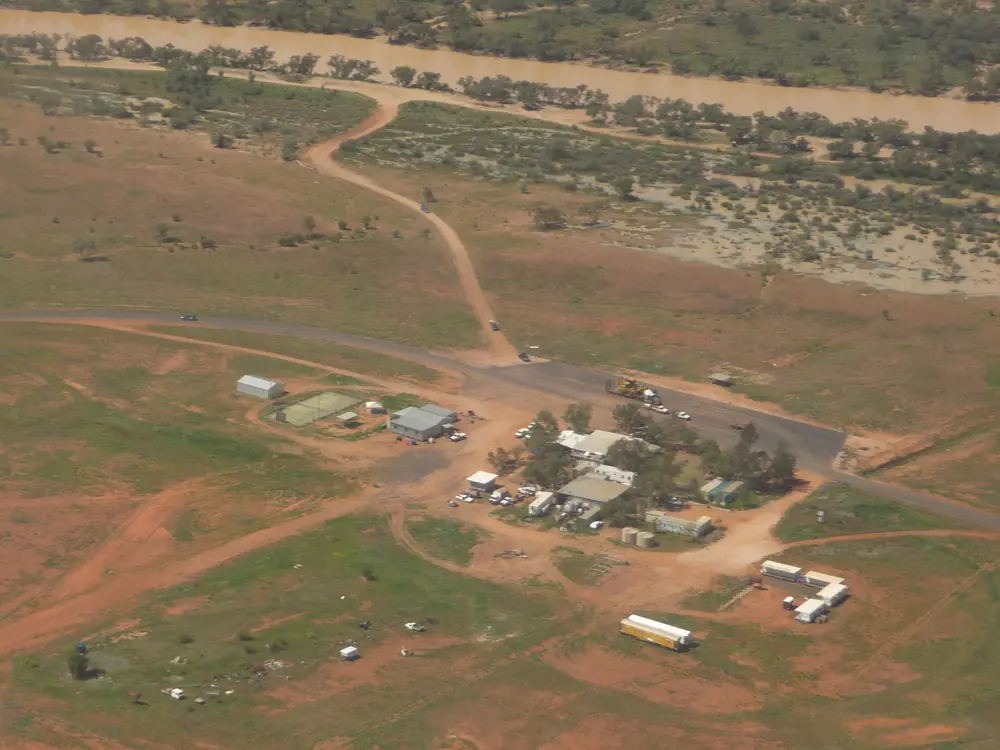
Aerial view of NoccundraPhoto: AdioPPoidA · CC BY-SA 4.0 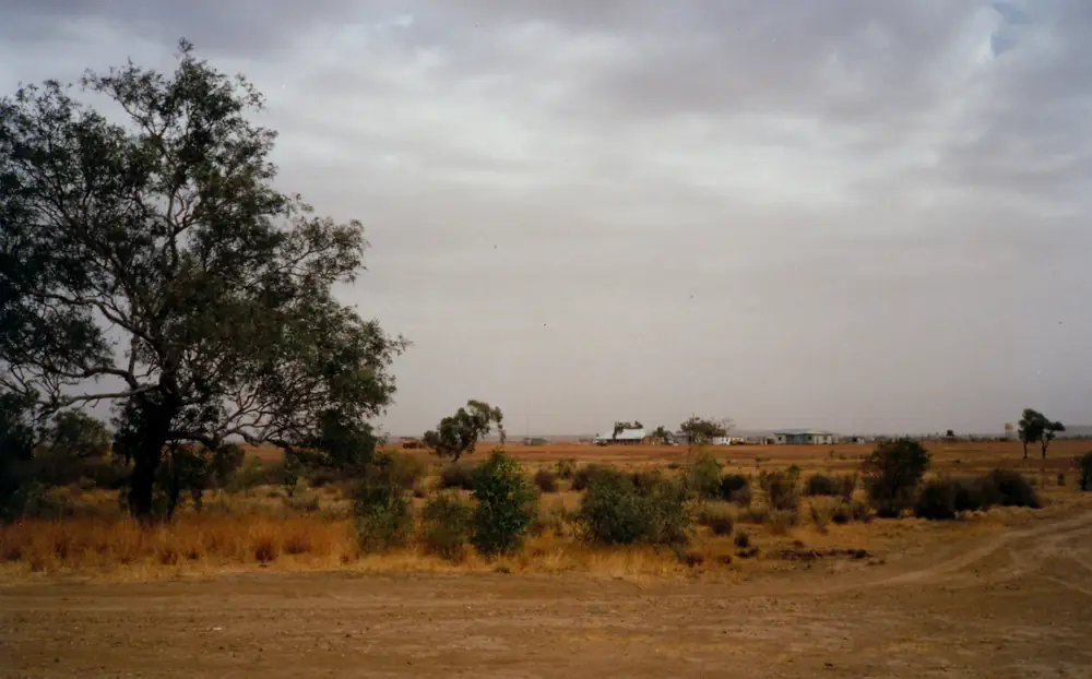
The Noccundra Hotel from the waterholePhoto: John Robert McPherson · CC BY-SA 4.0 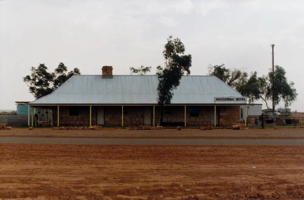
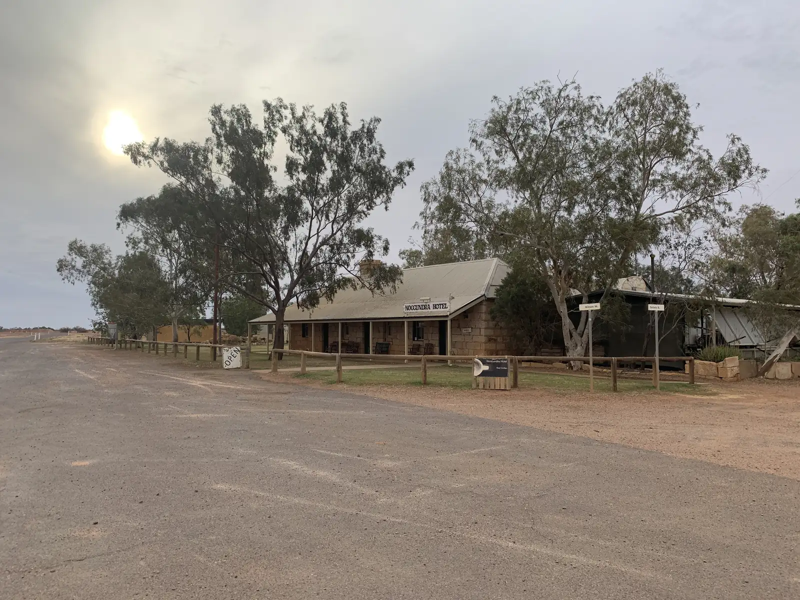
The Noccundra HotelPhoto: John Robert McPherson · CC BY-SA 4.0 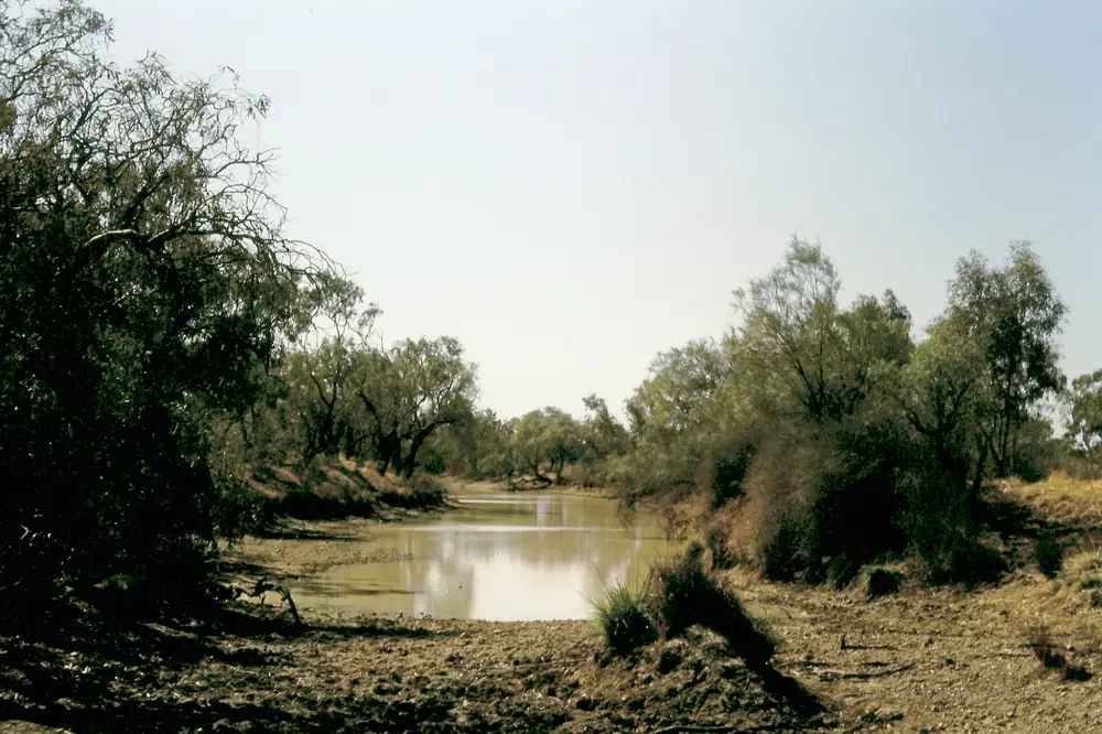
The Wilson River waterhole at NoccundraPhoto: John Robert McPherson · CC BY-SA 4.0
Noccundra is a tiny Bulloo Shire locality on the Wilson River in Queensland’s south-west, on the Adventure Way toward Corner Country. Explore Bulloo’s home page puts the township 142 km west of Thargomindah on the banks of the Wilson. Outback Queensland’s town page prints 140 km south-west of Thargomindah, 240 km north of Cameron Corner and 271 km east of Innamincka. Bulloo Shire’s About Council page prints 122 km west of Thargomindah, adjacent to the Noccundra Waterhole. This hub quotes those official figures rather than inventing a single kilometre.
The Australian Bureau of Statistics does not publish a 2021 Urban Centre (UCL) named Noccundra. Use suburbs-and-localities SAL32156: 16 people, median age 47, sex split 63.2% male / 36.8% female. QuickStats also prints 0 families and 10 private dwellings, and notes limited tables because of the small population. Bulloo Shire’s About Council page uses the same Census 16. A locality of 16 people does not have a high street of services this guide can invent.
West of Thargomindah the Adventure Way includes sealed and unsealed sections on this site’s Thargomindah guide. You need QLDTraffic, and South Australian outback road warnings if you are continuing to Innamincka. A 142 km run from Thargomindah is no use if the road is closed.
Where it is, and how far
Noccundra sits on the Adventure Way west of Thargomindah, with the Wilson River waterhole beside the hotel. Explore Bulloo’s hotel listing: 6 Wilson Street; unsealed airstrip YNCD directly behind the pub. Outback Queensland places the remnant township between the hotel, store remains and a Hume Expedition plaque.
This hub does not invent a Noccundra–Quilpie kilometre that is not on those pages. Quilpie is a boulder-opal neighbour in the wider south-west, not a 20-minute side road. Hungerford is Bulloo’s southern border town, 164 km south of Thargomindah on Explore Bulloo — a different spoke.
| Place | Distance from Noccundra (sourced) |
|---|---|
| Thargomindah | 142 km east (Explore Bulloo home); 140 km (Outback Queensland); 122 km (Bulloo About Council) |
| Cameron Corner | 240 km south (Outback Queensland) |
| Innamincka | 271 km west (Outback Queensland) |
Facts at a glance
Population. ABS 2021 Census, Suburbs and Localities SAL32156: 16 people. Median age 47. 0 families, 10 private dwellings. No UCL. Use the Noccundra SAL QuickStats.
Climate. BOM lists NOCCUNDRA HOTEL, 045057 on the Queensland rainfall-station directory (about 27.8180°S, 142.5900°E; July 1992–September 2026) and closed NOCCUNDRA POLICE STATION, 045013 (June 1913–December 1960). BOM does not publish a monthly climate-averages table for either site. The nearest published open table is Thargomindah Airport, 045025, commenced 1999, elevation 131 m, January mean maximum 38.9 °C, July 20.2 °C, annual rainfall 273.9 mm (26 years, 1999–2026). The longer closed table is Thargomindah Post Office, 045017, closed 16 March 2005: January 36.9 °C, July 19.2 °C, annual rainfall 286.3 mm. Full columns: BOM Thargomindah Airport. See Noccundra weather.
Visitor information. There is no Noccundra VIC on the sourced pages. Use the Thargomindah visitor desk, 37 Dowling Street, (07) 4621 8095, tourism@bulloo.qld.gov.au. Hotel phone on Explore Bulloo: 07 4655 4317.
Traditional Owners
Outback Queensland’s Noccundra page: during early exploration and settlement, the Wilson River Aboriginal Tribe, known as the Nockaburrawarry, lived in the area. That is visitor-guide wording on an official tourism page, not a native-title determination this hub can flatten onto one label. Bulloo Shire names a Kullilli Room in Thargomindah and does not print a separate nation for the Noccundra townsite on the About Council page used here. This guide quotes Outback Queensland’s Nockaburrawarry sentence and does not copy a shire-seat room name onto the Wilson. Confirm a sentence you want on a plaque with the Thargomindah desk.
History
Outback Queensland: the town started with, and will end with, the Heritage Listed Hotel. Built 1882 with sandstone mined at Mt Poole, near Milparinka NSW, and brought to Noccundra by camel train; gidgee verandah timber too hard to nail, so the roof is wired together. Explore Bulloo’s hotel page: built of locally quarried sandstone and transported by camel train; James Gardiner granted the first licence in 1886; heritage listed by the National Trust in 1977; owned by Nockatunga Station. This hub quotes both sandstone-origin sentences rather than picking one.
Outback Queensland: west of the hotel, remnants of the Noccundra General Store c1890–1970s; at one point the store building housed the pub and the hotel was used for accommodation and meals. Between store remains and hotel, a memorial plaque to the Andrew Hume Expedition, which passed the Noccundra Waterhole late 1874.
Explore Bulloo: the hotel has been a service point for travellers and a focus for community events, including Royal Flying Doctor Service medical and dental clinics and meetings of a social club and racing club that raise funds for the RFDS.
Things to do
Noccundra Hotel, 6 Wilson Street — the only original surviving building in the historic township on Explore Bulloo. Meals and snacks at the bar, dining room or beer garden; Waterhole Cafe 7.30 am–2.30 pm daily from March to October on that listing. Phone 07 4655 4317. See things to do in Noccundra.
Noccundra Waterhole / Wilson River — Outback Queensland: part of the Wilson; birds including grey grass wren, pelicans, brolgas, egrets, heron and painted honeyeater; yellowbelly, catfish, silver perch, blue claw yabbies and turtles. Queensland fisheries rules apply. Stay on the reserve the hotel page names.
Store remains and Hume plaque — named on Outback Queensland. Stay off unstable stone.
Airstrip YNCD — Explore Bulloo prints coordinates and a note that visitors fly in and taxi to the back door. That is an aviation note, not a car park.
There is no national park in Noccundra. Currawinya is Hungerford country. The Dig Tree and Innamincka are a separate Cooper Creek day from Innamincka.
Where to stay
Explore Bulloo’s Noccundra Hotel listing names:
- Dongas — double, twin and single rooms
- Powered and unpowered sites adjacent to the hotel
- Camping on the hotel lawns
- Free bush camping along the Noccundra Waterhole on the Wilson River Reserve
- Communal showers and toilets near the dongas; public toilets adjacent to the hotel
Those are official named types, not a ranked inventory. Confirm at 07 4655 4317 or (07) 4621 8095.
- How to choose: Noccundra accommodation
- Camping detail: Noccundra caravan parks
- Operator enquiries: feature your business
If Noccundra is full, Thargomindah is the last full-service town on this site’s Thargomindah guide before the long drive west. That is a planning fact, not a booking guarantee.
Caravan and camping
Vans use Noccundra as an Adventure Way overnight west of Thargomindah. Official named camps are the hotel park, the lawns, and the Wilson River Reserve bush camp. Ask the Thargomindah desk for stay limits. Read Noccundra caravan parks and outback camping.
After rain, the Wilson and the unsealed Adventure Way west are the constraint. QLDTraffic first.
Fuel and services
A locality of 16 people will not match Thargomindah for groceries or a hospital. Fuel is the fact to confirm, not to assume. Explore Bulloo’s current Noccundra Hotel listing names unleaded fuel and diesel. Bulloo Shire’s About Council page lists fuel among Noccundra amenities, with hotel, meals, camping, community hall, tennis courts, public toilets and an unsealed airstrip. This site’s Corner Country guide records that Noccundra has reportedly stopped selling fuel. Those sentences can both sit on official pages at once. Call 07 4655 4317 or (07) 4621 8095 before you leave Thargomindah. Fill up in Thargomindah. Carry enough to reach the next confirmed bowser, plus a reserve. See fuel, permits and road conditions.
Explore Bulloo also names EFTPOS, a public phone box (phone card only) and souvenirs. Confirm when you arrive.
Road access
The Adventure Way is the spine through Noccundra between Thargomindah and Innamincka. This site’s Thargomindah guide: sealed and unsealed sections, oil and gas fields, heavy vehicles. After rain, check QLDTraffic and 13 19 40, plus South Australian outback warnings west of the border. Do not drive around closed signs to keep a hotel meal.
East: Thargomindah, then Eulo and Cunnamulla on the Adventure Way. West: Dig Tree detour and Innamincka. South: Cameron Corner 240 km on Outback Queensland — unsealed Corner Country, not a sedan shortcut. Hungerford is the Dowling Track, not this road.
Nearby parks and towns
Parks and named nature sites:
- Noccundra Waterhole / Wilson River Reserve (Explore Bulloo; Outback Queensland)
- There is no national park in town. Currawinya is the Paroo wetland park via Hungerford. Innamincka Regional Reserve is a Cooper Creek trip from Innamincka
Towns on this site:
- Thargomindah — last full-service town east
- Hungerford — border gate, Currawinya approach
- Innamincka — 271 km on Outback Queensland
- Cameron Corner — 240 km
- Quilpie — boulder opal, further north-east in the region
When to go, and how long
Thargomindah Airport’s January mean maximum of 38.9 °C is hot for a waterhole walk at midday. July’s 20.2 °C mean maximum is the comfortable season; July’s 6.8 °C mean minimum is why a river camp needs a layer. Annual rainfall 273.9 mm on the open airport table is drier than Thargomindah Post Office’s closed-station 286.3 mm. Explore Bulloo’s Waterhole Cafe hours are March to October — a seasonal note sitting on top of the BOM mean.
Two hours at the hotel, store ruins and waterhole is the minimum. A night lets you use a donga or the river camp if the hotel has confirmed it. Two nights only if you are adding Innamincka or Cameron Corner and both jurisdictions’ road reports agree.
Operators who want a checked listing: feature your business. The listings slot on this hub stays empty until then.
Plan this trip
Tell us the dates, who you are travelling with and where you need help. We reply with planning notes for Noccundra — we are not a booking agent.
Events and road-conditions newsletter
Occasional notes on outback festivals, race days and official road-condition sources — not a daily blast. We use these details only to send the newsletter.
Queensland · South West
Noccundra accommodation
Where to stay in Noccundra: dongas, powered and unpowered sites and Wilson River bush camping named by Explore Bulloo. Confirm fuel and rooms before you leave Thargomindah.
Read · 3 min
Queensland · South West
Noccundra caravan parks
Camping in Noccundra: hotel powered sites, lawns and Wilson River Reserve bush camping as named by Explore Bulloo. Confirm roads and fuel before you leave Thargomindah.
Read · 3 min
Queensland · South West
Noccundra weather
Noccundra climate: BOM station 045057 has no monthly averages table. Use Thargomindah Airport (045025): January mean max 38.9 °C, July 20.2 °C, annual rainfall 273.9 mm.
Read · 5 min
Queensland · South West
Things to do in Noccundra
Things to do in Noccundra: heritage Noccundra Hotel, Wilson River waterhole birds, store ruins and the Hume Expedition plaque. Tiny locality, sourced list only.
Read · 4 min
Frequently asked questions
How far is Noccundra from Thargomindah, Innamincka and Cameron Corner?
Explore Bulloo’s home page puts Noccundra 142 km west of Thargomindah. Outback Queensland’s town page prints 140 km south-west of Thargomindah, 240 km north of Cameron Corner and 271 km east of Innamincka. Bulloo Shire’s About Council page prints 122 km west of Thargomindah. This hub quotes those official figures rather than inventing a single kilometre.
What is Noccundra’s population?
16 people at the 2021 Census for Noccundra suburbs-and-localities (SAL32156). The ABS does not publish a 2021 Urban Centre (UCL) named Noccundra. QuickStats notes limited tables because of the small population. Bulloo Shire’s About Council page uses the same Census 16.
Is there fuel at Noccundra?
Explore Bulloo’s Noccundra Hotel listing currently names unleaded fuel and diesel among hotel services. Bulloo Shire’s About Council page also lists fuel among Noccundra amenities. This site’s Corner Country guide records a report that Noccundra has stopped selling fuel. Confirm with the hotel or the Thargomindah visitor desk before you rely on a bowser.
Can I camp at Noccundra?
Yes, as named types. Explore Bulloo names dongas, powered and unpowered sites adjacent to the hotel, camping on the hotel lawns, and free bush camping along the Noccundra Waterhole on the Wilson River Reserve. Confirm when you arrive.
What is the weather like in Noccundra?
BOM lists Noccundra Hotel (045057) as a rainfall station but does not publish a monthly climate-averages table. Use Thargomindah Airport (045025): January mean maximum 38.9 °C, July 20.2 °C, annual rainfall 273.9 mm.
Where is the visitor centre?
There is no Noccundra visitor centre on the sourced pages. Use the Thargomindah visitor desk at 37 Dowling Street, (07) 4621 8095, tourism@bulloo.qld.gov.au.
Sources and further reading
Facts on this page were checked against these primary and official sources. Conditions change — confirm before you travel or buy.
- Noccundra 2021 Census QuickStats (SAL32156) — Australian Bureau of Statistics
- Climate statistics for Thargomindah Airport (045025) — Bureau of Meteorology
- Climate statistics for Thargomindah Post Office (045017) — Bureau of Meteorology
- Outback Queensland — Noccundra — Outback Queensland Tourism Association
- Noccundra Hotel — Explore Bulloo — Bulloo Shire Council
- About Council — Bulloo Shire — Bulloo Shire Council
- Explore Bulloo — Bulloo Shire Council
- QLDTraffic — Queensland Government