At a glance
Sourced facts only. Distances and services change — confirm before you travel.
- Local government
- Pastoral Unincorporated Area (Outback Communities Authority)
- Traditional Owners
- Not named for the Iron Knob townsite on the sourced Progress Association visitor pagesParks SA names the Gawler Ranges People as Traditional Owners of Gawler Ranges National Park (Barngarla, Kokatha and Wirangu foundation families). Whyalla VIC states it is on Barngarla Country. Confirm wording before using a single label for the Iron Knob townsite.
- Nearest regional city
- Iron Knob Progress Association: Whyalla 54 km SE; Port Augusta 73 km NE (fuel towns). Whyalla is the Spencer Gulf steel city on this site.
- Capital
- Parks SA puts Gawler Ranges National Park approximately six hours’ drive north-west of Adelaide. A surveyed Iron Knob–Adelaide kilometre is not printed on the Progress Association visitor page used here.
- Nearest fuel
- Iron Knob Progress Association: Iron Knob currently has no fuel available. Fill in Whyalla (54 km SE), Port Augusta (73 km NE) or Kimba (90 km SW).
- Nearest hospital or clinic
- Whyalla Hospital and Health Service, 20 Wood Terrace, 24-hour accident and emergency, (08) 8648 8300 (SA Health). Emergencies 000.
- Mobile coverage
- Check Telstra and Optus coverage maps before travel; Parks SA notes mobile coverage can be patchy in Gawler Ranges National Park.
- Best time to visit
- Parks SA Gawler Ranges: late autumn and winter for green country and walks; summer can be very hot. BOM Whyalla Aero January mean max 30.2 °C
Climate
Monthly means from the Bureau of Meteorology station Whyalla Aero (018120). This is not a forecast. BOM does not publish an Iron Knob climate-averages table on the South Australia site-name list used here. Nearest open complete gulf table used here is Whyalla Aero. Temperature 41 years (1945–2026); rainfall 38 years (1945–2026). Elevation 9 m. This is a Whyalla hinterland table, not a town AWS.
| Month | Mean max (°C) | Mean min (°C) | Rainfall (mm) |
|---|---|---|---|
| Jan | 30.2 | 17.9 | 19.8 |
| Feb | 29.7 | 17.8 | 21.3 |
| Mar | 27.4 | 15.8 | 17.8 |
| Apr | 24.1 | 12.0 | 20.3 |
| May | 20.5 | 8.7 | 22.5 |
| Jun | 17.3 | 6.2 | 27.5 |
| Jul | 17.0 | 5.3 | 21.9 |
| Aug | 18.6 | 6.1 | 21.8 |
| Sep | 21.8 | 8.2 | 24.1 |
| Oct | 24.2 | 10.9 | 23.8 |
| Nov | 26.5 | 14.0 | 23.2 |
| Dec | 28.3 | 16.0 | 24.3 |
Iron Knob in pictures
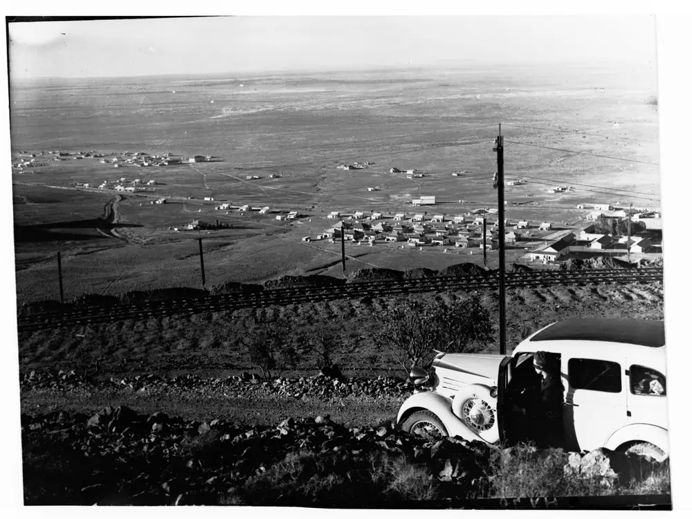
Historic Iron Knob townshipPhoto: Captain Frank Hurley · CC0 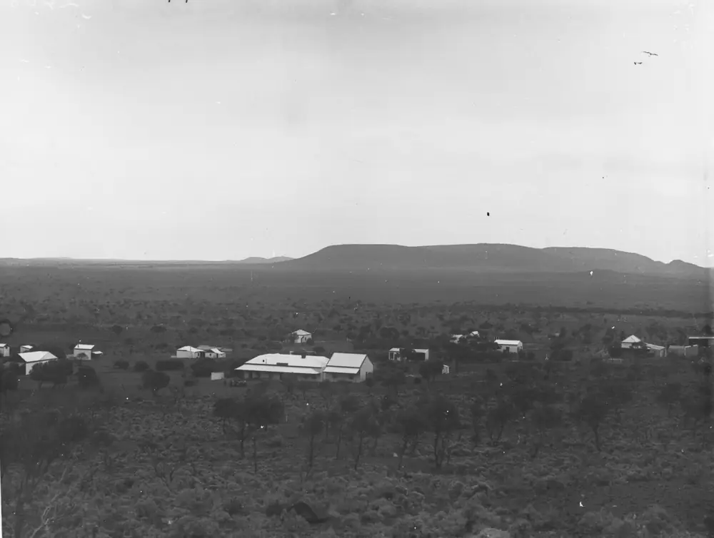
Houses at Iron KnobPhoto: State Government Photographer · CC0
Iron Knob is the Eyre Highway iron-ore town in South Australia’s Whyalla hinterland, in the Pastoral Unincorporated Area. The Iron Knob Progress Association’s visitor page is blunt: the mine is owned and operated by SIMEC; the main part of the town is not company land but freehold, proclaimed a township in February 1915; and Iron Knob currently has no fuel. This hub is that South Australian mining town, not a Western Australian namesake and not a Whyalla suburb. Whyalla is the Spencer Gulf steel city on the Lincoln Highway — a different road.
The Australian Bureau of Statistics does not publish a 2021 Urban Centre (UCL) named Iron Knob on the pages used here. Use suburbs-and-localities SAL40627: 110 people, median age 57, sex split 47.6% male / 52.4% female. 20 families, 95 private dwellings, average household size 1.7. QuickStats notes small-area confidentiality adjustments.
This site groups Iron Knob with Outback SA towns. Municipal services sit with the Outback Communities Authority. The Progress Association is the community page used here for fuel, the museum and camping.
Where it is, and how far
Iron Knob sits off the Eyre Highway between Port Augusta and Kimba, inland from Whyalla. The Progress Association prints three fuel towns, which this hub uses as the distance table: Whyalla 54 km SE, Port Augusta 73 km NE, Kimba 90 km SW. Parks SA’s Gawler Ranges National Park page puts that park 40 km north of the Eyre Highway, with road access from Iron Knob, Kimba, Wudinna or Minnipa, and about six hours’ drive north-west of Adelaide. Those park figures are park access, not a second Iron Knob–Adelaide survey.
SATC’s Mount Laura Homestead Museum in Whyalla names a steam locomotive that in 1902 hauled iron ore from Iron Knob to Hummock Hill. That is a Whyalla museum sentence, not an Iron Knob main-street walk.
| Place | Distance from Iron Knob (sourced) |
|---|---|
| Whyalla | 54 km SE (Iron Knob Progress Association visitor page; fuel) |
| Port Augusta | 73 km NE (same page; fuel) |
| Kimba | 90 km SW (same page; fuel) |
| Gawler Ranges National Park | Parks SA: 40 km north of the Eyre Highway; access includes Iron Knob |
| Adelaide | Parks SA: park about six hours north-west; no Iron Knob town kilometre on the Progress Association page used here |
Sealed highway: Traffic SA. Park tracks: Parks SA and DIT outback road warnings. Parks SA recommends a 4WD to enjoy all park highlights; in dry weather much of the park can be accessed by high-clearance 2WD.
Facts at a glance
Population. ABS 2021 SAL40627: 110 people. Median age 57. Use the Iron Knob SAL QuickStats.
Climate. No Iron Knob monthly climate-averages table on BOM’s South Australia list used here. Use Whyalla Aero (018120): 33.05°S, 137.52°E, elevation 9 m, commenced 1945, status open. January mean maximum 30.2 °C, July 17.0 °C, annual rainfall 259.5 mm. This is a gulf hinterland table, milder than Woomera’s inland January. Full columns: Iron Knob weather.
Visitor information. Progress Association Visitor Centre & Museum: weekdays 9:30am–3:30pm, admission free, phone 08 8646 2129. Whyalla VIC on SATC: Lincoln Highway entrance to the Maritime Museum, (08) 8645 7900. Parks SA Gawler Ranges office (08) 8648 1883.
Traditional Owners
A Traditional Owner nation named for the Iron Knob townsite was not on the Progress Association visitor pages fetched for this rebuild. Parks SA’s Gawler Ranges National Park page states the Gawler Ranges People are recognised as Traditional Owners of that Country, attaining native title in 2011, a distinct group of foundation families made up of some, but not all, the Barngarla, Kokatha and Wirangu People. Whyalla’s visitor centre states it is on Barngarla Country. This hub does not flatten those park and city sentences onto Iron Knob’s freehold streets. Confirm wording at the museum or Whyalla VIC. Read visiting Country respectfully.
History
The Progress Association: township proclaimed February 1915; the mine is now SIMEC; the town faced changes when the mine temporarily closed between the mid 1990s and 2013. SATC’s Whyalla museum listing is the warrant to name the 1902 iron-ore locomotive to Hummock Hill. This is an iron-ore town, not a wheatbelt railway anecdote borrowed from Kimba and not a Stuart Highway roadhouse.
OCA is the unincorporated-area warrant. The Progress Association runs the museum and the camping grounds behind the Post Office. This hub does not invent a visitor count, a star rating, or a public mine-tour timetable — the Association’s “Mine & Town Tours” menu item did not return a page when fetched for this rebuild, so it is not treated as a bookable product here.
Things to do
Visitor Centre & Museum. Progress Association: historic mining displays, mineral specimens (hematite, turquoise, quartz and others named on that page), a theatrette that presents the story of mining in Iron Knob, souvenirs and iron-ore jewellery. Free. Weekdays 9:30am–3:30pm. Phone 08 8646 2129. Confirm it is actually open; a locality of 110 people does not keep city hours.
Community camping grounds. Behind the Post Office. RVs, caravans, tents and swags. No fee; donations appreciated. See Iron Knob caravan parks.
Gawler Ranges National Park. Parks SA: Organ Pipes, Yandinga Falls, Kolay Mirica Falls, yellow-footed rock-wallabies, vehicle entry and camping fees. Access includes Iron Knob. Dogs not permitted. Book before you go.
Whyalla hinterland. SATC’s Mount Laura Homestead Museum is in Whyalla Norrie, not in Iron Knob. Steelworks tours, cuttlefish and HMAS Whyalla live on the Whyalla hub.
See things to do in Iron Knob.
Where to stay
Named stay types on official pages used here:
- Community camping grounds behind the Post Office — Progress Association; donation, not a ranked holiday park
- Whyalla hotel, motel and caravan-park types — 54 km SE; the steel-city overflow
- Port Augusta rooms — 73 km NE
- Park camping in Gawler Ranges National Park — Parks SA fees, not a town park
This hub does not invent an Iron Knob motel chain. How to choose: Iron Knob accommodation. Operator enquiries: feature your business.
Caravan and camping
A van can sit on sealed Eyre Highway approaches in ordinary weather. The Progress Association camping grounds are the in-town named option. Parks SA campgrounds in the Gawler Ranges are park camps with vehicle entry. Read Iron Knob caravan parks and outback camping.
Fill with fuel before you arrive. There are no bowsers in town on the Association’s own sentence.
Fuel and services
No fuel. That is the Progress Association’s current visitor-page sentence. Fill in Whyalla (54 km), Port Augusta (73 km) or Kimba (90 km). A locality of 110 people will not match Whyalla for groceries or a hospital. Whyalla Hospital, 20 Wood Terrace, (08) 8648 8300, 24-hour accident and emergency (SA Health). Emergencies 000.
Post Office / Rural Transaction Centre: Lot 783 Dickenson Street, weekdays except Tuesday on the Association’s hours table, 08 8646 2064. Confirm before you treat it as a bank.
Road access
Eyre Highway sealed toward Port Augusta and Kimba / Ceduna. Traffic SA. Whyalla is on the Lincoln Highway — do not mix the two names. Parks SA park tracks: 4WD recommended for all highlights; high-clearance 2WD in dry weather; closed on catastrophic fire-danger days. DIT for unsealed outback roads.
Our Nullarbor guide is the Eyre Highway crossing page. Iron Knob is a hinterland iron-ore stop on the way, not a Nullarbor roadhouse.
Nearby parks and towns
Parks and named nature:
- Gawler Ranges National Park — Parks SA; access from Iron Knob
Towns on this site:
- Whyalla — 54 km SE, steel city, hospital
- Port Augusta — 73 km NE
- Kimba — 90 km SW, halfway-across-Australia Eyre Highway town
- Outback SA hub
When to go, and how long
Parks SA: late autumn and winter the park is green and cool; summer can be very hot. Whyalla Aero’s January mean maximum of 30.2 °C is milder than inland Stuart Highway January, still a sun problem on mine-red hills. July 17.0 °C / 5.3 °C is the cooler museum day. See Iron Knob weather.
An hour covers the museum if it is a weekday. A night covers the donation camp if you already have fuel. The Gawler Ranges are a separate park day, not a town walk.
Operators who want a checked listing: feature your business. The listings slot stays empty until then.
Plan this trip
Tell us the dates, who you are travelling with and where you need help. We reply with planning notes for Iron Knob — we are not a booking agent.
Events and road-conditions newsletter
Occasional notes on outback festivals, race days and official road-condition sources — not a daily blast. We use these details only to send the newsletter.
South Australia · Outback SA
Iron Knob accommodation
Where to stay in Iron Knob: Progress Association camping grounds behind the Post Office (donation). No invented motel strip. Whyalla is 54 km. Fill with fuel first — there are no bowsers.
Read · 3 min
South Australia · Outback SA
Iron Knob caravan parks
Camping in Iron Knob: Progress Association grounds behind the Post Office, donation, RVs and tents. Parks SA Gawler Ranges camps are separate. No fuel in town. Confirm before you unhitch.
Read · 3 min
South Australia · Outback SA
Iron Knob weather
Iron Knob climate from BOM Whyalla Aero (018120): January mean max 30.2 °C, July 17.0 °C, annual rainfall 259.5 mm. No Iron Knob-named table. Whyalla hinterland, not a Stuart Highway blend.
Read · 3 min
South Australia · Outback SA
Things to do in Iron Knob
Things to do in Iron Knob: Progress Association museum and theatrette, community camping, Gawler Ranges National Park access. No fuel in town. Whyalla hinterland, not Iron Knob WA.
Read · 3 min
Frequently asked questions
Is this Iron Knob in South Australia or Western Australia?
This hub is Iron Knob in South Australia’s Pastoral Unincorporated Area, the Eyre Highway iron-ore town in the Whyalla hinterland. It is not a Western Australian town page. Whyalla is the Spencer Gulf steel city on this site.
What is Iron Knob’s population?
110 people at the 2021 Census for Iron Knob suburbs-and-localities (SAL40627). Median age 57. Sex split 47.6% male / 52.4% female. The ABS does not publish a 2021 Urban Centre named Iron Knob on the pages used here.
Can I buy fuel in Iron Knob?
No. The Iron Knob Progress Association visitor page states Iron Knob currently has no fuel available. Fill in Whyalla (54 km SE), Port Augusta (73 km NE) or Kimba (90 km SW) on that same page.
What is there to do in Iron Knob?
The Progress Association names a Visitor Centre and Museum (historic mining displays, theatrette, free admission, weekdays 9:30am–3:30pm) and community camping grounds behind the Post Office. Parks SA lists Iron Knob as a road-access town for Gawler Ranges National Park. SATC’s Mount Laura Homestead Museum in Whyalla names a steam locomotive that in 1902 hauled iron ore from Iron Knob to Hummock Hill.
Whose Country is nearby?
Parks SA’s Gawler Ranges National Park page states the Gawler Ranges People are recognised as Traditional Owners of that Country, attaining native title in 2011, a distinct group of foundation families made up of some, but not all, the Barngarla, Kokatha and Wirangu People. Whyalla VIC states it is on Barngarla Country. This hub does not flatten those sentences onto the Iron Knob townsite.
What weather record should I use?
BOM does not publish an Iron Knob climate-averages table. Use Whyalla Aero (018120): January mean maximum 30.2 °C, July 17.0 °C, annual rainfall 259.5 mm.
Sources and further reading
Facts on this page were checked against these primary and official sources. Conditions change — confirm before you travel or buy.
- Iron Knob 2021 Census QuickStats (SAL40627) — Australian Bureau of Statistics
- Climate statistics for Whyalla Aero (018120) — Bureau of Meteorology
- Visitor Information — Iron Knob — Iron Knob Progress Association
- Visitor Centre & Museum — Iron Knob — Iron Knob Progress Association
- Camping Grounds — Iron Knob — Iron Knob Progress Association
- Gawler Ranges National Park — National Parks and Wildlife Service SA
- Mount Laura Homestead Museum — South Australian Tourism Commission
- Whyalla Hospital and Health Service — SA Health
- Outback Communities Authority — Outback Communities Authority
- Traffic SA — Government of South Australia
- Outback road warnings — Department for Infrastructure and Transport SA