At a glance
Sourced facts only. Distances and services change — confirm before you travel.
- Population
- 2,353 people (UCL115044, 2021 Census)
- Local government
- Coonamble Shire
- Traditional Owners
- Kamilaroi and Wailwan peopleCoonamble Shire Community Strategic Plan 2025–2035. An older council annual report uses the Weilwan spelling.
- Nearest regional city
- Dubbo, less than two hours by road (Visit NSW; Coonamble Shire CSP). A Coonamble–Dubbo kilometre is not printed on those pages.
- Capital
- Sydney, a little over six hours (Visit NSW); six hours (Coonamble Shire CSP). A Coonamble–Sydney kilometre is not printed on those pages.
- Nearest fuel
- Service town — confirm bowsers in Coonamble; this guide does not name a brand
- Nearest hospital or clinic
- Coonamble Health Service, 150 Castlereagh Street — 24-hour emergency (NSW Health / Western NSW LHD)
- Mobile coverage
- Check Telstra and Optus coverage maps before travel; do not assume a signal on shire back roads or in the Marshes.
- Best time to visit
- May–September (cooler BOM Coonamble Airport mean maxima). Visit NSW’s Coonamble Rodeo and Campdraft is a June long weekend.
Climate
Monthly means from the Bureau of Meteorology station Coonamble Airport AWS (051161). This is not a forecast. Open. Commenced 1997. Elevation 181 m. Temperature 29 years (1997–2026); rainfall 25 years (1997–2026).
| Month | Mean max (°C) | Mean min (°C) | Rainfall (mm) |
|---|---|---|---|
| Jan | 35.4 | 20.5 | 45.2 |
| Feb | 34.0 | 19.5 | 51.8 |
| Mar | 31.2 | 17.2 | 56.0 |
| Apr | 26.4 | 12.1 | 35.4 |
| May | 21.6 | 7.5 | 36.3 |
| Jun | 17.8 | 5.1 | 45.0 |
| Jul | 17.2 | 3.7 | 31.2 |
| Aug | 19.4 | 4.2 | 24.0 |
| Sep | 23.9 | 7.5 | 29.3 |
| Oct | 27.8 | 11.6 | 40.8 |
| Nov | 30.9 | 15.5 | 60.0 |
| Dec | 33.3 | 18.0 | 63.6 |
Coonamble in pictures
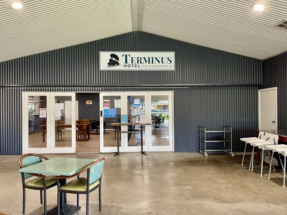
Terminus Hotel on Castlereagh Street in townPhoto: Kgbo · CC BY-SA 4.0 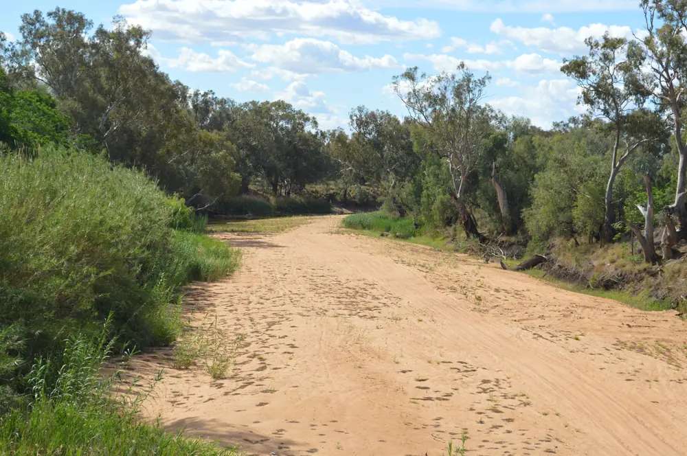
Castlereagh River at CoonamblePhoto: Mattinbgn · CC BY 3.0 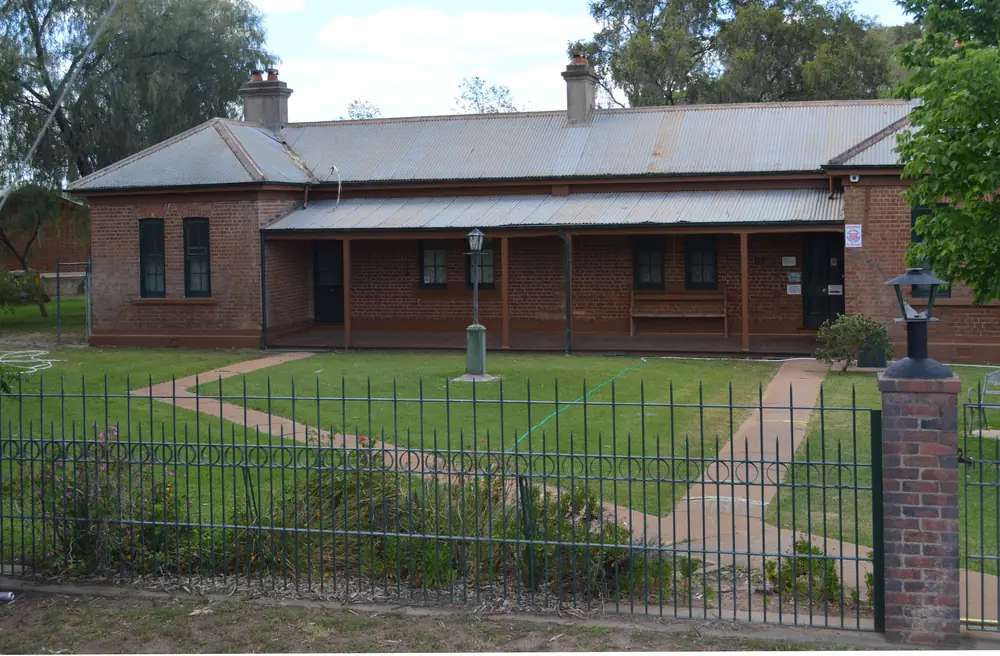
Coonamble Historical Museum buildingPhoto: Mattinbgn · CC BY 3.0 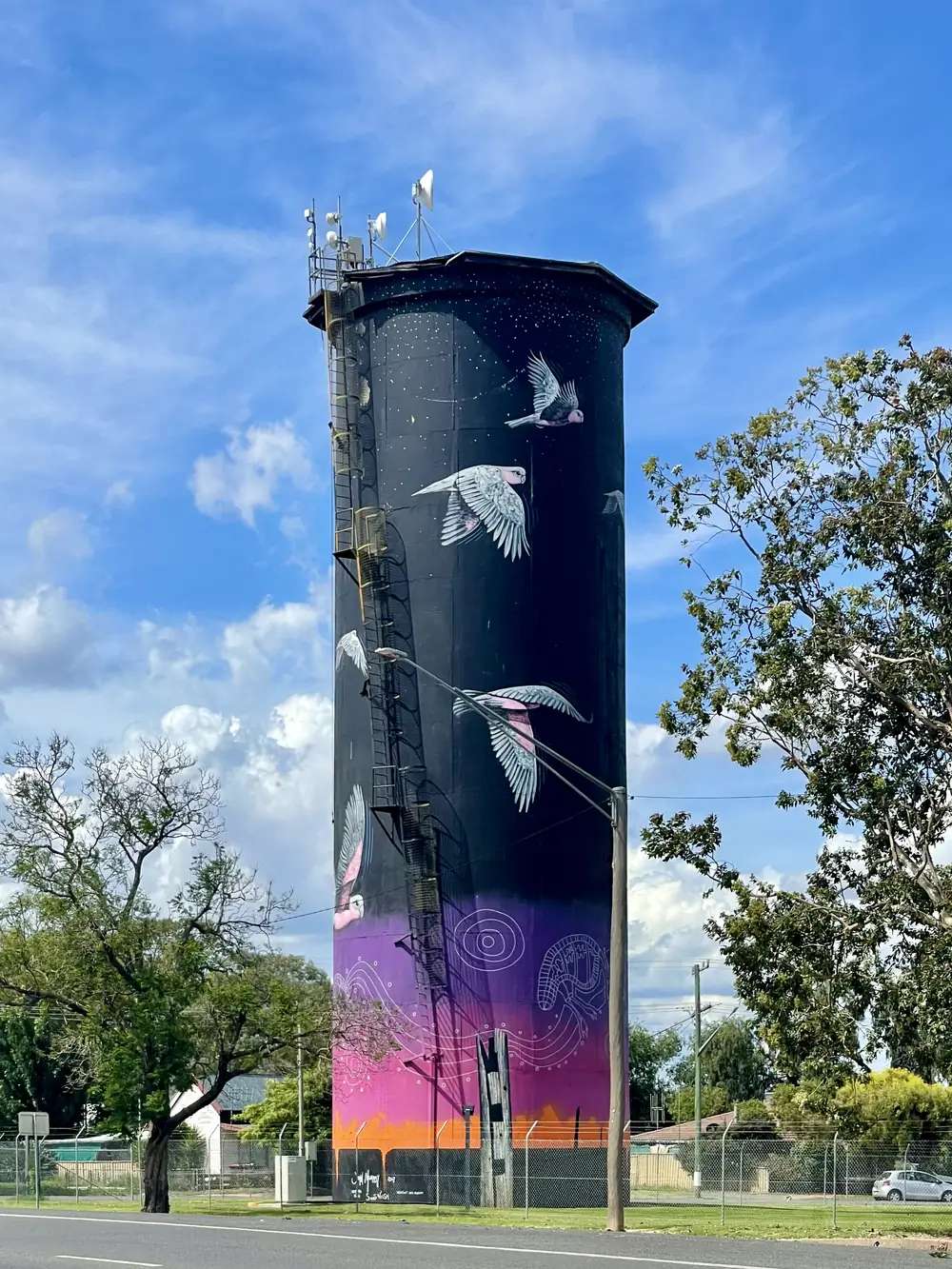
Town water-tower mural in CoonamblePhoto: Kgbo · CC BY-SA 4.0
Coonamble is a Castlereagh River town in Coonamble Shire, on this site’s Explorer Country belt west of the Warrumbungles. Visit NSW’s Coonamble page is the Destination NSW listing used here: country hospitality, Australia’s biggest rodeo and campdraft, a raft of pubs, and a gateway to three named natural wonders — Warrumbungle National Park, the Macquarie Marshes and Pilliga Forest. The same page calls Coonamble Australia’s nickname capital. Coonamble Shire’s own visit page adds the Aboriginal word ‘lot of dirt’, dryland cropping with cattle and sheep, and a new Information & Exhibition Centre at 120 Castlereagh Street, across from the water-tower mural. This hub is the shire town. It is not Coonabarabran, not the forest discovery centre in Baradine, and not a Lightning Ridge opal street.
Use the urban-centre Census for the town. The 2021 urban centre Coonamble, UCL115044, counted 2,353 people, median age 37, sex split 49.1% male / 50.9% female. 534 families, 1,166 private dwellings. Aboriginal and/or Torres Strait Islander people were 1,016 (43.2%) of the UCL. Suburbs-and-localities SAL11044 counted 2,666, median age 38, 611 families, 1,296 dwellings, Indigenous 1,054 (39.5%). Coonamble Shire LGA12150 counted 3,732 for the whole local government area — that figure includes Gulargambone and Quambone. Do not add the codes together. Read the ABS UCL QuickStats.
The Castlereagh Highway is sealed in ordinary weather. After rain on the river or on Marshes roads, you still need Live Traffic NSW. Fill in town before you treat a Quambone or forest spur as a sedan loop.
Where it is, and how far
Coonamble sits on the Castlereagh River, which Coonamble Shire’s Community Strategic Plan says runs through the town and divides east from west. The same plan puts the LGA at 9,955 square kilometres, bounded by Walgett to the north, Warrumbungle in the east, Gilgandra to the south and Warren in the west. Visit NSW puts the town halfway between Dubbo and Lightning Ridge. The scenic drive north from Dubbo on the Newell and Castlereagh highways via Gilgandra and Gulargambone is less than two hours. The drive from Sydney is a little over six hours. You can also fly into Dubbo and rent a car. Those pages do not print a Coonamble–Dubbo or Coonamble–Sydney kilometre; this hub does not invent one.
| Place | Distance from Coonamble (sourced) |
|---|---|
| Dubbo | less than two hours north-from-Dubbo drive (Visit NSW; Coonamble Shire CSP). Kilometre not printed on those pages |
| Sydney | a little over six hours (Visit NSW); six hours (CSP). Kilometre not printed |
| Lightning Ridge | the northern hinge on Visit NSW’s “halfway between Dubbo and Lightning Ridge” wording; a separate Coonamble kilometre is not on that page |
| Gulargambone | Visit NSW’s Gulargambone Hotel listing puts Gulargambone approximately 45 kilometres from Coonamble |
| Coonamble Airport AWS (BOM) | 30.98°S, 148.38°E, elevation 181 m — climate station at the airport, not a drive time |
Gilgandra is named on Visit NSW’s drive, not linked — this site has no Gilgandra town page. Quambone is named on Visit NSW for the Sundowner Hotel near the Marshes, not linked.
Facts at a glance
Population. ABS 2021 UCL115044: 2,353 people. Median age 37. 43.2% Aboriginal and/or Torres Strait Islander. No mixing with SAL 2,666 or LGA 3,732. Coonamble UCL QuickStats.
Climate. COONAMBLE AIRPORT AWS, 051161, 30.98°S, 148.38°E, elevation 181 m, commenced 1997, status open, latest data 14 Nov 2026 on the table fetched here. Mean maximum (29 years, 1997–2026): January 35.4 °C, July 17.2 °C, annual 26.6 °C. Mean minimum (29 years): January 20.5 °C, July 3.7 °C, annual 11.9 °C. Mean rainfall (25 years, 1997–2026): annual 529.9 mm. Mean days of rain ≥ 1 mm: 49.2. Wettest mean month December 63.6 mm; driest August 24.0 mm. See Coonamble weather.
Visitor information. Coonamble Information & Exhibition Centre, 120 Castlereagh Street, across from the water-tower mural — Coonamble Shire visit page. Administration 80 Castlereagh Street, (02) 6827 1900, council@coonambleshire.nsw.gov.au.
Traditional Owners
Coonamble Shire’s Community Strategic Plan 2025–2035 acknowledges the Kamilaroi and Wailwan people as the traditional custodians of the land on which it meets and operates, respecting Elders past, present and emerging, and states that the LGA is located on the traditional Indigenous lands of the Wailwan and Kamilaroi people. The shire visit page records ‘Coonamble’ as the Aboriginal word for ‘lot of dirt’. An older council annual report used the Weilwan spelling. This hub follows the current CSP wording rather than flattening two groups onto one label. Confirm at 120 Castlereagh Street. NPWS’s Macquarie Marshes Nature Reserve page separately names the Wailwan People for that wetland; that is a reserve acknowledgement, not a substitute for the townsite.
History
Coonamble Shire’s visit page says Coonamble and the villages of Gulargambone and Quambone were originally established to service farmers, their families and agricultural workers. Visit NSW’s town page is lighter on dates and heavier on living culture: nicknames so thick that “the ‘real’ names of most locals have been forgotten”, celebrated on the Nickname Hall of Fame billboards. The Museum Under the Bridge sits in a former colonial police station on the Castlereagh. This facts file does not invent a gazettal year that those pages do not print.
The Coonamble Rodeo and Campdraft is the event Visit NSW uses to mark the calendar: a long weekend every June, recognised as the largest combined rodeo/campdraft in the Southern Hemisphere, with more than 1,000 cowboys and cowgirls and thousands of spectators. Campdrafting is described there as uniquely Australian. Confirm the year’s dates with the Information & Exhibition Centre rather than treating a past program as a booking.
Things to do
Castlereagh River walk to the Museum Under the Bridge — Visit NSW: artefacts, photographs, implements and household utensils from early Coonamble.
Outback Arts Gallery — local and regional artists including up-and-coming Indigenous artists; workshops; Outback Archies Annual Art Prize and Exhibition. Hours change; ask at 120 Castlereagh Street.
Coonamble Water Tower — Visit NSW: 25 metres high, painted by John Murray and Sooty Welsh, pink and grey galahs, fence posts, sun, moon and Southern Cross. Aboriginal Dreamtime artwork on the tank by local artist Sooty Walsh (Visit NSW prints both Welsh and Walsh).
Nickname Hall of Fame — street billboards of local characters and nicknames.
Pubs named by Visit NSW — Sons of the Soil, Bucking Bull and Terminus in Coonamble; Sundowner Hotel in Quambone, near the Marshes. Named types, not a bar crawl we ranked.
Coonamble Rodeo and Campdraft — June long weekend on Visit NSW.
Macquarie Marshes — Visit NSW: when flowing, one of Australia’s most significant waterbird nesting sites; kayaking or birding tours; Ramsar-listed wetlands; threatened brolga, painted snipe and Australasian bittern among species named. NPWS’s reserve page is stricter: the nature reserve is around 80 km north of Warren and 30 km west of Quambone, access limited to management and research staff, no visitor facilities, guided wading walks in April, September or October 2026 and guided kayak tours. Do not treat the reserve as a self-drive picnic ground.
Warrumbungle Range — east of Coonamble on Visit NSW: Allan Cunningham, Cunningham’s campsite, Pandoras Pass, Australia’s first Dark Sky Park. Use the Coonabarabran hub and stargazing. A Coonamble–park kilometre is not on the Visit NSW Coonamble page used here.
Pilliga Forest — named as the third natural neighbour. The village baths sit in Pilliga; the discovery centre sits in Baradine.
See things to do in Coonamble.
Where to stay
Visit NSW: places to stay range from a riverside caravan park to hotels and motels. Coonamble Shire’s older annual report names Riverside Caravan Park on the Castlereagh Highway. Ask the Information & Exhibition Centre (02) 6827 1900. This hub will not invent motel brands, star ratings or prices.
- How to choose: Coonamble accommodation
- Camping detail: Coonamble caravan parks
- Operator enquiries: feature your business
If Coonamble is full on the June rodeo weekend, Gulargambone is the Castlereagh Highway neighbour Visit NSW puts approximately 45 km away, and Dubbo is the regional overflow less than two hours south. Those are geometry facts, not booking guarantees.
Caravan and camping
Vans use Coonamble as a Castlereagh Highway overnight between Dubbo and Lightning Ridge, or as a base for Marshes tours that NPWS actually offers. The sourced in-town type is the riverside caravan park named by Visit NSW and council. Confirm stay limits, dump points and whether the river bank is open after flood. Read Coonamble caravan parks and outback camping.
After rain, the Castlereagh and the Marshes are the constraint. Live Traffic NSW first. The NPWS Macquarie Marshes reserve has no visitor facilities and is not a free camp.
Fuel and services
A UCL of 2,353 people is a genuine service town on this highway: fuel, groceries and a hospital exist in a way Enngonia or Come By Chance do not. This guide still does not list bowser brands. Fill here before a Quambone, Marshes or Pilliga spur. Coonamble Health Service, 150 Castlereagh Street, is a NSW Health multipurpose service with 24-hour emergency, inpatient and residential aged-care beds, medical imaging, renal dialysis, obstetrics and community health — phone (02) 6822 9300. For current visitor questions, use Coonamble Shire Council and (02) 6827 1900.
Road access
The Castlereagh Highway is the sealed spine through Coonamble between Gulargambone / Dubbo to the south and Walgett / Lightning Ridge to the north. Visit NSW’s approach from Dubbo also uses the Newell Highway as far as Gilgandra. It is a freight road. Pull over for road trains. After rain on the Castlereagh, check Live Traffic NSW. Do not drive around closed signs to keep a rodeo or Marshes booking.
East: Warrumbungle country and Coonabarabran. West: Quambone and the Marshes — NPWS access rules apply. North: Walgett then Lightning Ridge. South: Gulargambone then Dubbo. Nyngan is a Mitchell Highway neighbour in the wider west, not a 20-minute side road this hub will invent a kilometre for.
Nearby parks and towns
Parks and named nature sites:
- Castlereagh River banks (Visit NSW walk)
- Macquarie Marshes Nature Reserve — NPWS: limited access, Wailwan Country, Ramsar 1986, 80 km north of Warren / 30 km west of Quambone
- Warrumbungle National Park — east; Dark Sky Park on Visit NSW
- Pilliga Forest — named neighbour; village and discovery centre are separate towns on this site
Towns on this site:
- Gulargambone — approximately 45 km; corrugated-iron galahs
- Dubbo — less than two hours; regional airport and zoo-scale services
- Coonabarabran — Astronomy Capital / Warrumbungle gateway
- Baradine and Pilliga — forest and bore-bath pair
- Walgett and Lightning Ridge — north on the Castlereagh
Named, not linked: Gilgandra, Quambone, Warren.
When to go, and how long
Coonamble Airport’s January mean maximum of 35.4 °C is hot for a river walk and a water-tower photograph at midday. July’s 17.2 °C mean maximum is the comfortable walking season on paper; July’s 3.7 °C mean minimum is why a riverside night needs a layer. Annual rainfall 529.9 mm is wetter than Bourke Airport’s table used on this site’s far-west hubs. A half day covers the tower, Nickname Hall of Fame and museum. A night lets you use a hotel or the riverside park if the VIC has confirmed a site. Two nights if you are adding a booked Marshes tour, a Warrumbungle day via Coonabarabran, or the June rodeo — and Live Traffic NSW agrees.
Winter is when Visit NSW’s rodeo sits on the calendar. NPWS Marshes guided walks are named for April, September or October 2026, not for a self-drive summer picnic.
Operators who want a checked listing: feature your business. The listings slot on this hub stays empty until then.
Plan this trip
Tell us the dates, who you are travelling with and where you need help. We reply with planning notes for Coonamble — we are not a booking agent.
Events and road-conditions newsletter
Occasional notes on outback festivals, race days and official road-condition sources — not a daily blast. We use these details only to send the newsletter.
New South Wales · Explorer Country
Coonamble accommodation
Where to stay in Coonamble: Visit NSW names a riverside caravan park plus hotels and motels. Confirm at the Information & Exhibition Centre, 120 Castlereagh Street. No invented brands.
Read · 4 min
New South Wales · Explorer Country
Coonamble caravan parks
Camping in Coonamble: Visit NSW names a riverside caravan park. Confirm stay limits at the Information & Exhibition Centre. Macquarie Marshes Nature Reserve is not a free camp.
Read · 3 min
New South Wales · Explorer Country
Coonamble weather
Coonamble climate from BOM Coonamble Airport AWS (051161): January mean max 35.4 °C, July 17.2 °C, annual rainfall 529.9 mm. Open station since 1997. Live Traffic NSW after rain.
Read · 4 min
New South Wales · Explorer Country
Things to do in Coonamble
Things to do in Coonamble: Museum Under the Bridge, Outback Arts, 25-metre water tower mural, Nickname Hall of Fame, June rodeo, Castlereagh River. Marshes and Warrumbungles are neighbouring days, not main-street loops.
Read · 5 min
Frequently asked questions
How far is Coonamble from Dubbo and Sydney?
Visit NSW puts Coonamble halfway between Dubbo and Lightning Ridge. The scenic drive north from Dubbo on the Newell and Castlereagh highways via Gilgandra and Gulargambone is less than two hours. The drive from Sydney is a little over six hours. Coonamble Shire’s Community Strategic Plan 2025–2035 repeats less than two hours from Dubbo and six hours from Sydney. Those pages do not print a Coonamble kilometre to either city.
What is Coonamble’s population?
2,353 people at the 2021 Census for the urban centre Coonamble, UCL115044, median age 37. Suburbs-and-localities SAL11044 counted 2,666, median age 38. Coonamble Shire LGA12150 counted 3,732. Do not mix the three geographies.
What is there to do in Coonamble?
Visit NSW names the Castlereagh River walk to the Museum Under the Bridge, the Outback Arts Gallery, the 25-metre water tower mural by John Murray and Sooty Welsh / Sooty Walsh, the Nickname Hall of Fame, pubs including the Sons of the Soil, Bucking Bull and Terminus, and the June Coonamble Rodeo and Campdraft. Neighbouring natural areas named on that page are Warrumbungle National Park, the Macquarie Marshes and Pilliga Forest.
Where should I stay in Coonamble?
Visit NSW says places to stay range from a riverside caravan park to hotels and motels. Coonamble Shire’s Information & Exhibition Centre at 120 Castlereagh Street is the desk to ask. This hub does not invent extra motel brands.
What is the weather like in Coonamble?
BOM Coonamble Airport AWS (051161, open): January mean maximum 35.4 °C, July 17.2 °C, annual rainfall 529.9 mm. Elevation 181 m. Commenced 1997.
Whose Country is Coonamble on?
Coonamble Shire’s Community Strategic Plan 2025–2035 acknowledges the Kamilaroi and Wailwan people as the traditional custodians of the land on which it meets and operates, and locates the LGA on the traditional Indigenous lands of the Wailwan and Kamilaroi people. Confirm current wording at the Information & Exhibition Centre.
Sources and further reading
Facts on this page were checked against these primary and official sources. Conditions change — confirm before you travel or buy.
- Coonamble (UCL115044) 2021 Census QuickStats — Australian Bureau of Statistics
- Coonamble (SAL11044) 2021 Census QuickStats — Australian Bureau of Statistics
- Coonamble (LGA12150) 2021 Census QuickStats — Australian Bureau of Statistics
- Climate statistics for Coonamble Airport AWS (051161) — Bureau of Meteorology
- Coonamble, Warrumbungle area — Destination NSW
- Visit Coonamble — Coonamble Shire Council
- Coonamble Shire Community Strategic Plan 2025–2035 — Coonamble Shire Council
- Coonamble Health Service — NSW Government / Western NSW Local Health District
- Macquarie Marshes Nature Reserve — NSW National Parks and Wildlife Service
- Live Traffic NSW — Transport for NSW