At a glance
Sourced facts only. Distances and services change — confirm before you travel.
- Local government
- Central Desert Regional Council
- Traditional Owners
- Central Desert Regional Council: Ti Tree and its surrounds are part of the Anmatjere language group. The Anmatjere name for the area close to Ti Tree is Aleyaw.Council also names Pmara Jutunta (Six Mile), Nturiya (Station) and Wilora (Stirling), plus smaller outstations. Keep that list as neighbouring communities, not flattened onto the townsite.
- Nearest regional city
- Alice Springs, about 200 km south (Central Desert Regional Council Anmatjere page). Tourism NT’s Alice Springs camping page puts Prowse Gap 145 km north of Alice Springs and 45 km south of the next supply stop at Ti Tree.
- Capital
- NT Government rest-stop table prints Darwin 1345 km from Prowse Gap, 45 km south of Ti Tree on Tourism NT. A Darwin kilometre named for the Ti Tree townsite was not on the sourced council or Tourism NT town pages.
- Nearest fuel
- Central Desert Regional Council: Ti Tree offers several shops where you can find fuel and other necessities. Confirm the bowser on arrival; this hub does not invent a brand or hours.
- Nearest hospital or clinic
- Central Desert Regional Council names a remote health clinic in Ti Tree. NT Police: the community health centre provides primary health care via Aboriginal health workers, registered nurses and a visiting district medical officer.
- Mobile coverage
- Check Telstra and Optus coverage maps before travel; do not assume a signal in the ranges either side of town.
- Best time to visit
- May–August cooler means on BOM Territory Grape Farm (015643): July mean max 22.8 °C, mean min 5.2 °C. Station is 42 km from Ti-Tree township on BOM’s daily observations note.
Climate
Monthly means from the Bureau of Meteorology station Territory Grape Farm (015643). This is not a forecast. Open station. Temperature 32 years (1987–2026); rainfall 33 years (1987–2026). Latest available data 14 November 2026. BOM daily observations note Territory Grape Farm is 42 kilometres from Ti-Tree township.
| Month | Mean max (°C) | Mean min (°C) | Rainfall (mm) |
|---|---|---|---|
| Jan | 37.6 | 22.3 | 63.4 |
| Feb | 36.4 | 21.8 | 56.3 |
| Mar | 34.6 | 19.8 | 31.1 |
| Apr | 30.9 | 14.5 | 14.7 |
| May | 25.5 | 9.6 | 22.2 |
| Jun | 22.5 | 6.3 | 8.4 |
| Jul | 22.8 | 5.2 | 6.4 |
| Aug | 25.5 | 7.0 | 4.5 |
| Sep | 30.3 | 11.9 | 10.6 |
| Oct | 33.6 | 15.9 | 16.2 |
| Nov | 35.6 | 19.2 | 31.8 |
| Dec | 36.6 | 21.4 | 59.8 |
Ti Tree in pictures
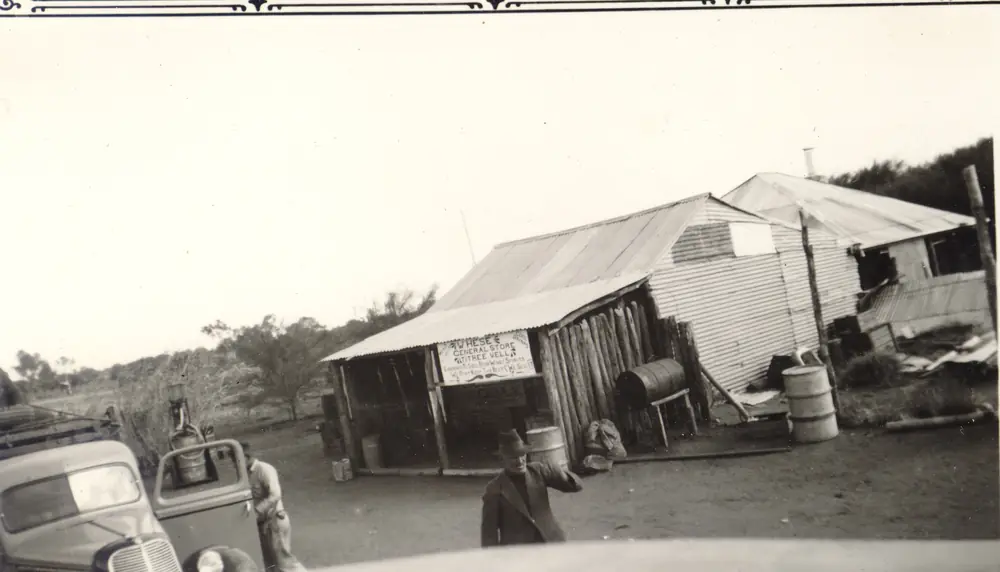
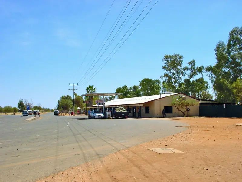
Historic general store at Ti TreePhoto: Donald and Isabel Dowling · CC BY-SA 4.0 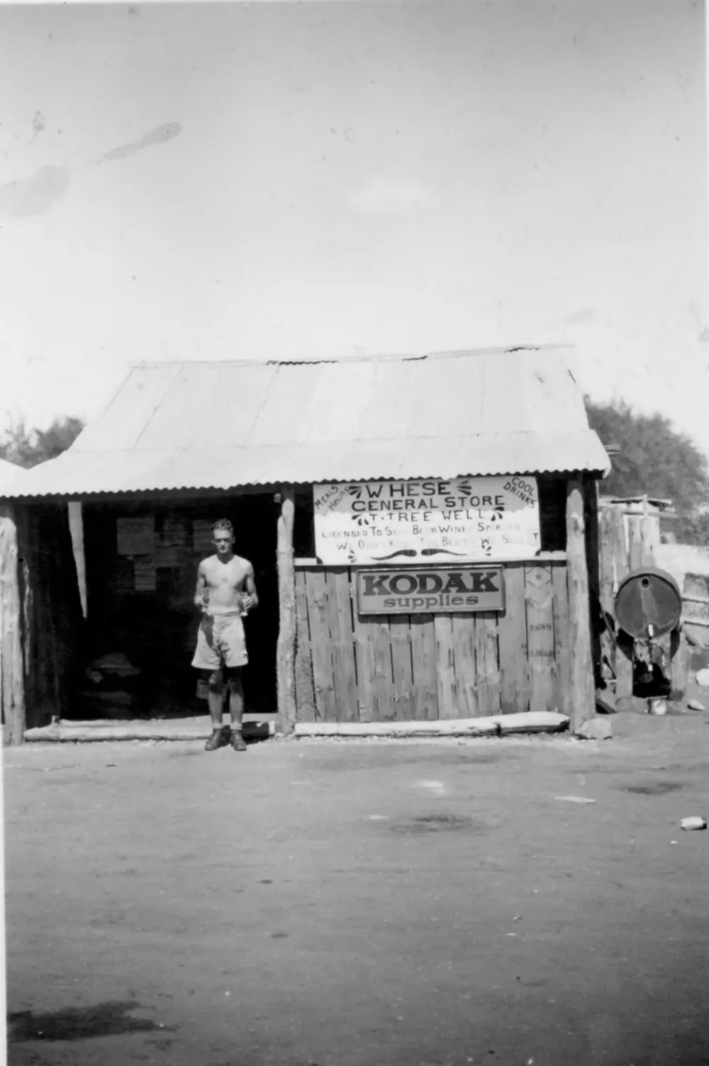
Historic store at Ti TreePhoto: Chas Wales · CC BY-SA 4.0
Ti Tree is a Stuart Highway Anmatyerr town in the Red Centre listing on this site, about 200 kilometres north of Alice Springs on Central Desert Regional Council’s Anmatjere page. Tourism NT’s Alice Springs camping page puts Prowse Gap 145 km north of Alice Springs and 45 km south of the next supply stop at Ti Tree. This hub is the town on the Track, not a waterfall page for Litchfield and not a second Alice Springs desert-park day. Darwin is the capital; it has no town page here.
Central Desert Regional Council’s community sentence is the geography used here. Ti Tree and its surrounds are part of the Anmatjere language group, which includes Pmara Jutunta (Six Mile), Nturiya (Station) and Wilora (Stirling), plus smaller outstations including Adelaide Bore, Alyuen, Petyale and Woods Camp. Combined, Anmatjere has a population of around 550. The Anmatjere name for the area close to Ti Tree is Aleyaw. NT Place Names records the official town naming as Ti-Tree (gazetted 15 May 1981, named 22 April 1983). This site’s slug is ti-tree. Older telegraph records used Tea Tree Well. Keep those spellings as history, not as a second town.
The Australian Bureau of Statistics does not publish a 2021 Urban Centre (UCL) named Ti Tree. Use suburbs-and-localities SAL70256: 88 people, median age 36, sex split 36.4% male / 63.6% female. 12 families, 70 private dwellings. QuickStats notes limited tables because of the small population. Do not mix the SAL 88 with council’s combined Anmatjere around 550. You still need the NT Road Report after rain.
Where it is, and how far
Ti Tree sits on the public sealed Stuart Highway, on the same corridor as our Stuart Highway and Adelaide to Darwin guides. NT Police: the community sits on flat plains with the Reynolds Ranges to the south-west and Watt Ranges to the north-east. South, Alice Springs is the next large Red Centre town on this site. Tourism NT names Prowse Gap Rest Area 45 km south of Ti Tree. Further south again, Connors Well sits 92 km north of Alice Springs on that camping page, near Aileron. North, the Stuart continues toward Tennant Creek. Karlu Karlu / Devils Marbles belongs to Tennant Creek’s own guide — this hub does not add 200 km to that park kilometre and call the sum a Ti Tree distance.
| Place | Distance from Ti Tree (sourced) |
|---|---|
| Alice Springs | about 200 km south (Central Desert Regional Council) |
| Prowse Gap Rest Area | 45 km south (Tourism NT camping page); 145 km north of Alice Springs |
| Territory Grape Farm BOM station | 42 km from Ti-Tree township (BOM daily observations note) |
A separate Ti Tree–Tennant Creek kilometre was not on those sourced town pages, so this hub does not invent one. Tourism NT’s Food Barn listing uses approximately halfway between Alice Springs and Tennant Creek without printing that kilometre.
Facts at a glance
Population. ABS 2021 Census SAL70256: 88 people. Median age 36. Limited tables. Use Ti Tree QuickStats. Council’s around 550 is Anmatjere combined.
Climate. TERRITORY GRAPE FARM, 015643, 22.45°S, 133.64°E, elevation 566 m, commenced 1987, status open, latest available data 14 November 2026. Mean maximum (32 years, 1987–2026): January 37.6 °C (hottest month by mean max), June 22.5 °C coolest mean max — not July (22.8 °C). Mean minimum: January 22.3 °C, July 5.2 °C, annual 14.6 °C. Mean rainfall (33 years, 1987–2026): annual 320.8 mm. Mean days of rain ≥ 1 mm: 30.5. BOM notes the station is 42 km from Ti-Tree township. See Ti Tree weather.
Visitor information. Central Desert Regional Council’s Anmatjere page and NT Police’s Ti Tree station profile are the official community listings used here. Council Anmatjere phone: 08 8966 9900. Roads: NT Road Report.
Traditional Owners
Central Desert Regional Council: Ti Tree and its surrounds are part of the Anmatjere language group. The Anmatjere name for the area close to Ti Tree is Aleyaw. Neighbouring named communities on that page are Pmara Jutunta (Six Mile), Nturiya (Station) and Wilora (Stirling). This guide follows that council wording rather than inventing a second nation label. Stay on public roads. Aboriginal land needs Central Land Council permits those agencies print. See visiting Country respectfully.
NT Place Names: in 1994 the Town of Ti-Tree was incorporated into the Anmatjere Community Government Council. That is the local-government history behind today’s Central Desert Regional Council Anmatjere ward.
History
NT Place Names: a well on the banks of the Woodforde Creek was named Tea Tree Well during construction of the Overland Telegraph Line, believed named because the well sat among “tea tree” bushes in the creek. In the 1920s, with pastoral expansion north of Alice Springs, William Heffernan founded Ti Tree Station some miles west of the well, and a store was set up by Lily Hese at Tea Tree Well. In early 1980 the community requested, by petition to the Legislative Assembly, that the spelling change from Tea Tree to Ti-Tree. The town area was gazetted 15 May 1981; the town was officially named Ti-Tree on 22 April 1983 (NTG18, 6 May 1983).
NT Police: cattle stations and horticulture are the region’s main industries, with Ti Tree Farm, Central Australian Produce Farm and seven other grape farms producing table grapes for the Australian market. That is a police industry sentence, not a cellar-door trail this hub will invent hours for.
Tourism NT’s wartime “Long Journey” article names Ti Tree as a convoy lunch stop whose small store sold beer, drunk in an underground dining room. That is a 1940s highway memory, not a current restaurant booking.
Things to do
Official named things to do are modest. This is a highway service town of 88 people.
- Aleyaw / Anmatjere Country — read council wording; stay on public roads
- Shops, fuel and takeaway — Central Desert Regional Council
- Remote health clinic, police, Central Land Council office, library — council and NT Police
- Grape horticulture on the plains — NT Police industry note; this is working farmland, not a public orchard walk unless an operator says so
- Ti Tree Football Club (Roosters) — NT Police; Central Australian Country Cup in Alice Springs
Nearby, not in-town: NT Police name Ryan’s Well Historical Reserve, Glen Maggie Homestead ruins and Central Mount Stuart. NT Government’s rest-stop table puts Ryans Well 123 km north of Alice Springs and Central Mount Stuart Historical Reserve 215 km north of Alice Springs. Tourism NT names the 17 m high Anmatjere man sculpture at Aileron, near Connors Well. See things to do in Ti Tree.
Where to stay
Tourism NT names Ti Tree Food Barn and Accommodation: a quiet outback getaway in a fully fenced secure location off the Stuart Highway, approximately halfway between Alice Springs and Tennant Creek, with cabins. Central Desert Regional Council names shops and takeaway. This guide does not invent extra motels. If the town is full, Alice Springs is about 200 km south and Prowse Gap is a named 24-hour rest area 45 km south.
- How to choose: Ti Tree accommodation
- Camping detail: Ti Tree caravan parks
- Operator enquiries: feature your business
Caravan and camping
The Stuart Highway is sealed. Tourism NT names cabins at the Food Barn listing and Prowse Gap Rest Area 45 km south as 24-hour free camping with BBQs, picnic tables, non-drinking water, shelter and toilets; generators and pets welcome on that page. Confirm stay limits in town. Read Ti Tree caravan parks and outback camping.
Fuel and services
A town of 88 people will not match Alice Springs for a hospital. Central Desert Regional Council names several shops where you can find fuel, takeaway, a remote health clinic, police station, Central Land Council office, library, Centrelink and a council office. NT Police describe the health centre as primary care with Aboriginal health workers, registered nurses and a visiting district medical officer. This guide does not list bowser brands. Fill in Alice Springs if you are unsure. Council Anmatjere: 08 8966 9900.
Road access
Stuart Highway sealed north–south. NT Road Report is the authority. Stay on gazetted roads. Central Land Council permits apply on Aboriginal land and private community roads. Our Stuart Highway and Adelaide to Darwin guides are the road-trip pages.
Nearby parks and towns
Parks and reserves (nearby, not in-town):
- Ryan’s Well Historical Reserve and Central Mount Stuart Historical Reserve — named by NT Police as Ti Tree attractions; NT Government rest-stop kilometres sit on those reserves’ own tables
- Karlu Karlu / Devils Marbles — via Tennant Creek, not a Ti Tree main-street walk
Towns on this site:
- Alice Springs — about 200 km south
- Tennant Creek — north on the Stuart
- Harts Range — Plenty Highway east of this corridor, not a Ti Tree suburb
- Barrow Creek — Stuart Highway telegraph reserve north of Ti Tree
When to go, and how long
Territory Grape Farm’s January mean maximum of 37.6 °C is a Red Centre summer. July’s 22.8 °C mean maximum and 5.2 °C mean minimum, with August’s 4.5 mm, is the cool Dry on a 320.8 mm annual table. June, not July, holds the lowest mean maximum (22.5 °C). Two hours covers fuel, a cabin check and a stretch of the legs. A night covers the named Food Barn stay if a cabin exists. Ryan’s Well and Central Mount Stuart are separate highway hours, not town walks.
Operators who want a checked listing: feature your business. The listings slot on this hub stays empty until then.
Plan this trip
Tell us the dates, who you are travelling with and where you need help. We reply with planning notes for Ti Tree — we are not a booking agent.
Events and road-conditions newsletter
Occasional notes on outback festivals, race days and official road-condition sources — not a daily blast. We use these details only to send the newsletter.
Northern Territory · Red Centre
Things to do in Ti Tree
Things to do in Ti Tree: Anmatjere / Aleyaw Country, highway services, grape horticulture. NT Police name Ryan’s Well, Glen Maggie ruins and Central Mount Stuart as nearby attractions. Red Centre, not a Darwin page.
Read · 4 min
Northern Territory · Red Centre
Ti Tree accommodation
Where to stay in Ti Tree: Tourism NT names Ti Tree Food Barn and Accommodation cabins off the Stuart Highway. Prowse Gap rest area is 45 km south. Confirm before you unhitch. Red Centre, not Darwin.
Read · 3 min
Northern Territory · Red Centre
Ti Tree caravan parks
Camping near Ti Tree: Tourism NT names Prowse Gap Rest Area 45 km south as 24-hour free camping. In town, Tourism NT names Food Barn cabins. Confirm before you unhitch. Anmatjere Red Centre.
Read · 3 min
Northern Territory · Red Centre
Ti Tree weather
Ti Tree climate from BOM Territory Grape Farm (015643), 42 km from township: January mean max 37.6 °C, July 22.8 °C, annual rainfall 320.8 mm. Open station. Anmatjerr Red Centre.
Read · 3 min
Frequently asked questions
How is Ti Tree spelled, and whose Country is it?
This hub uses Ti Tree. NT Place Names: the community petitioned in early 1980 to change the spelling from Tea Tree to Ti-Tree; the town was officially named Ti-Tree on 22 April 1983. The site slug is ti-tree. Central Desert Regional Council: Ti Tree and its surrounds are part of the Anmatjere language group, and the Anmatjere name for the area close to Ti Tree is Aleyaw.
How far is Ti Tree from Alice Springs?
Central Desert Regional Council’s Anmatjere page puts Ti Tree about 200 kilometres north of Alice Springs along the sealed Stuart Highway. Tourism NT’s Alice Springs camping page puts Prowse Gap Rest Area 145 km north of Alice Springs and 45 km south of the next supply stop at Ti Tree. Confirm the day’s drive on the NT Road Report.
What is Ti Tree’s population?
88 people at the 2021 Census for Ti Tree suburbs-and-localities (SAL70256), median age 36, sex split 36.4% male / 63.6% female. QuickStats notes limited tables because of the small population. The ABS does not publish a 2021 Urban Centre named Ti Tree. Central Desert Regional Council’s combined Anmatjere figure of around 550 is the wider group of communities, not this SAL.
What is there to do in Ti Tree?
Central Desert Regional Council names council services, a clinic, police, a Central Land Council office, shops with fuel and takeaway. NT Police name Ryan’s Well Historical Reserve, Glen Maggie Homestead ruins and Central Mount Stuart as attractions, plus grape horticulture on the plains. Those named reserves sit on the Stuart corridor — confirm they are not treated as Ti Tree main-street walks.
What is the weather like in Ti Tree?
BOM Territory Grape Farm (015643, open): January mean maximum 37.6 °C, July 22.8 °C, annual rainfall 320.8 mm (33 years, 1987–2026). Temperature means use 32 years (1987–2026). BOM notes the station is 42 kilometres from Ti-Tree township. Latest available data 14 November 2026.
Can I camp at Ti Tree?
Tourism NT lists Ti Tree Food Barn and Accommodation as a named stay type off the Stuart Highway, approximately halfway between Alice Springs and Tennant Creek, with cabins. Tourism NT’s camping page names Prowse Gap Rest Area 45 km south of Ti Tree as a 24-hour free camping site. Confirm sites when you arrive rather than assuming a 24-hour park sheet in town.
Sources and further reading
Facts on this page were checked against these primary and official sources. Conditions change — confirm before you travel or buy.
- Ti Tree 2021 Census QuickStats (SAL70256) — Australian Bureau of Statistics
- Climate statistics for Territory Grape Farm (015643) — Bureau of Meteorology
- Anmatjere — Central Desert Regional Council
- Ti Tree (Place Names Register, id 18964) — NT Place Names Register
- Ti Tree — NT Police, Fire and Emergency Services
- Ti Tree Food Barn and Accommodation — Tourism NT
- Camping around Alice Springs — Tourism NT
- Road rest stops in NT — Northern Territory Government
- NT Road Report — Northern Territory Government