At a glance
Sourced facts only. Distances and services change — confirm before you travel.
- Local government
- Tablelands Regional Council
- Traditional Owners
- Tablelands Regional Council’s new-residents page names Wurrungu of the Gunnawarra/Goshen area among Native Title parties in the region. Goondaloo (Warrungnu) Aboriginal Corporation RNTBC, which administers land on behalf of the Warrungnu People, lists an office at 20 Garnet Street, Mount Garnet. This guide does not flatten neighbouring Jirrbal country at Innot Hot Springs onto the townsite.
- Mobile coverage
- Check Telstra and Optus coverage maps before travel; do not assume a signal.
- Best time to visit
- May–September on Herberton cooler mean maxima (labelled comparison). Mount Garnet Races and Rodeo: first weekend in May (Tropical Tablelands Tourism).
Climate
Monthly means from the Bureau of Meteorology station Herberton Mowbray Rd (031029). This is not a forecast. Closed 26 Nov 2015. Labelled Tablelands temperature comparison — Mt Garnet Post Office (031046) is rainfall-only. Do not blend the two. Elevation 909 m.
| Month | Mean max (°C) | Mean min (°C) | Rainfall (mm) |
|---|---|---|---|
| Jan | 28.0 | 18.2 | 239.2 |
| Feb | 27.3 | 18.3 | 234.7 |
| Mar | 26.3 | 17.5 | 211.3 |
| Apr | 24.6 | 15.6 | 84.4 |
| May | 22.9 | 13.2 | 46.2 |
| Jun | 21.5 | 10.6 | 33.7 |
| Jul | 21.4 | 9.7 | 22.3 |
| Aug | 22.7 | 10.1 | 17.7 |
| Sep | 24.9 | 12.0 | 16.3 |
| Oct | 27.5 | 14.3 | 26.5 |
| Nov | 28.6 | 16.2 | 79.6 |
| Dec | 28.9 | 17.5 | 138.5 |
Mount Garnet, Queensland in pictures
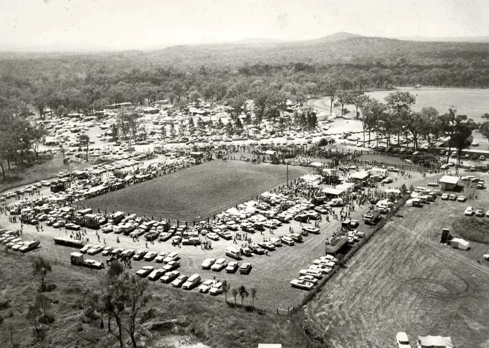
Rodeo Grounds Mt Garnet in Mount GarnetPhoto: Atiptop · CC BY-SA 3.0 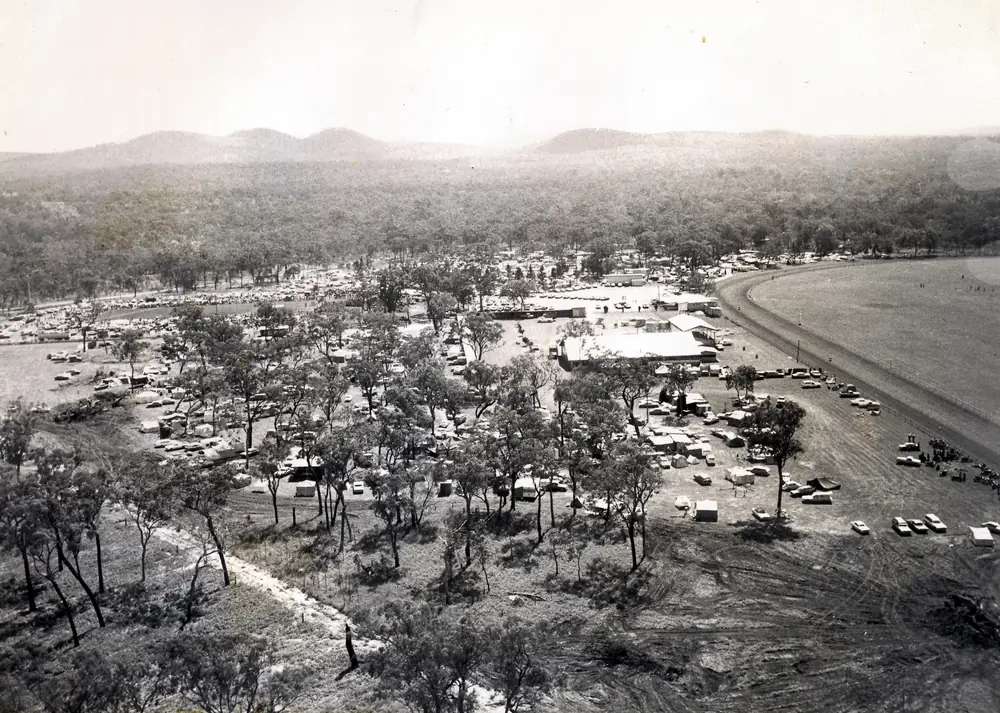
Mt Garnet Racecourse in Mount GarnetPhoto: Atiptop · CC BY-SA 3.0 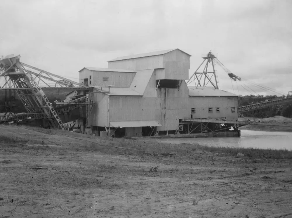
Tin dredge at Mount GarnetPhoto: Item is held by John Oxley Library, State Library of Queensland. · Public domain
Mount Garnet, Queensland — also written Mt Garnet — sits in the Tablelands Region on the western fringe of the Atherton Tablelands, on the Savannah Way west of Ravenshoe. Tropical Tablelands Tourism’s destination page is the source for that placement. This is not a New South Wales locality. Search Mount Garnet Qld if a search engine offers the wrong state first.
The 2021 Census counted 253 people in the urban centre and 532 in the wider locality. Travellers stop for designated fossicking country, Wurruma Swamp, and the Mount Garnet Races and Rodeo on the first weekend in May. Innot Hot Springs is the named thermal neighbour on the Kennedy Highway between Ravenshoe and Mount Garnet; this hub does not invent a kilometre those pages do not print. You still need QLDTraffic in the wet, because a Savannah Way run toward Mount Surprise is no use if the highway is closed.
Where it is, and how far
Mount Garnet is the Savannah Way town at the western edge of Tablelands Regional Council, between the rainforest Tablelands and Etheridge Shire’s Gulf Savannah. Tropical Tablelands Tourism places it west of Ravenshoe. Innot Hot Springs sits on the Kennedy Highway between Ravenshoe and Mount Garnet on the same organisation’s Innot page. The pages used for this guide do not print a Mount Garnet–Ravenshoe, Mount Garnet–Innot, Mount Garnet–Cairns or Mount Garnet–Georgetown kilometre. Do not invent one.
| Place | Distance from Mount Garnet (official pages used here) |
|---|---|
| Ravenshoe | west of Ravenshoe on the Savannah Way (Tropical Tablelands Tourism); no kilometre on that page |
| Innot Hot Springs | on the Kennedy Highway between Ravenshoe and Mount Garnet (same organisation’s Innot page); no kilometre on the sources used here |
| Cairns | not published as a Mount Garnet kilometre on those pages. The Innot page describes Innot as about a two-hour drive south-west of Cairns — that figure is for Innot, not for Mount Garnet |
| Mount Surprise / Undara | not published as a Mount Garnet kilometre on the Tablelands pages used here |
| Brisbane | not published on those pages |
Mareeba is the larger Tablelands neighbour on this site. Georgetown is the Etheridge headquarters further west on the Savannah Way. Use QLDTraffic for the day you drive.
Facts at a glance
Population. Australian Bureau of Statistics 2021 Census, Urban Centres and Localities UCL322084, Mount Garnet (L): 253 people. Median age 50. Sex split 49.4% male / 50.6% female (126 male, 129 female). Families 62. Private dwellings 155. Average household size 2.4. Median weekly household income $854. Use the ABS UCL QuickStats page. The suburbs-and-localities geography (SAL31965) counted 532 people, median age 50, 116 families, 293 private dwellings, median weekly household income $921. Do not mix the two.
Climate. Bureau of Meteorology station MT GARNET POST OFFICE, 031046, opened 1901, status Open, 17.68°S, 145.12°E, elevation 658 m. The Climate Data Online monthly rainfall table fetched for this guide prints all-years means: annual 823.4 mm; February 201.1 mm wettest mean month; January 191.9 mm; September 6.8 mm driest. Median annual 786.3 mm. Highest annual total in that table 1463.1 mm; lowest 238.6 mm. BOM does not publish a temperature climate-averages table for this site. For a Tablelands comparison table, use Herberton Mowbray Rd, 031029, clearly labelled as a different, higher, closed station. See Mount Garnet weather.
Visitor information. Tablelands Regional Council describes a network of five information centres across the region. There is no Mount Garnet VIC named on the Tropical Tablelands Tourism destination page used here. Use Ravenshoe Visitor Centre & Nganyaji Interpretive Centre, 22–24 Moore Street, phone 4089 2243, Monday–Saturday 9am–3pm, Sunday closed — the southern-Tablelands desk on trc.qld.gov.au/explore/information-centres. The Atherton Tablelands Information Centre, 1A Herberton Road, Atherton, 1300 366 361, is listed 9am–4pm seven days on the same page. Hours change. This hub does not invent a Mount Garnet street address for a centre the sourced pages do not print.
Traditional Owners
Tablelands Regional Council’s new-residents page recognises nine Native Title parties across the region and names Wurrungu of the Gunnawarra/Goshen area. Gunnawarra is the neighbouring locality on the ABS geography used for this research. Goondaloo (Warrungnu) Aboriginal Corporation RNTBC administers land on behalf of the Warrungnu People and lists an office at 20 Garnet Street, Mount Garnet, on the Wet Tropics Plan contacts page. Visit as a guest; see visiting Country respectfully.
Queensland’s Country Culture map for Jirrbal names Innot Hot Springs among Jirrbal Country. That is a neighbouring thermal township, not a reason to flatten Jirrbal onto the Mount Garnet townsite. This guide follows the council and corporation pages for Mount Garnet and leaves Innot’s Jirrbal wording on the Innot side of the Kennedy Highway.
History
Tropical Tablelands Tourism’s Mount Garnet page is the town-origin source used here. The town developed after copper and garnets were discovered in the area in 1882. Mining continued into the early 1900s before the Mount Garnet Freehold Copper and Silver Mining Company closed, with activity returning when tin mining began in 1928. Mining remains part of the district today, with zinc, copper, lead, silver and lime among the resources extracted in the area. For visitors, the same page calls Mount Garnet a base for fossicking, birdwatching and exploring the western reaches of the Atherton Tablelands.
This hub does not invent a production-ounce table, a 1882 street map or a pub name the destination page does not print.
Things to do
Fossicking. Tropical Tablelands Tourism: designated fossicking areas in mineral-rich country that has attracted prospectors since the late 1800s. A Queensland fossicking licence is required on designated fossicking areas. Hand tools. Stay off mining claims and leases without the holder’s permission. This page does not name individual gullies the destination page does not name. Read fossicking and gem fields.
Wurruma Swamp. An important local wetland and a birdwatching stop near Mount Garnet on that page. The swamp holds water long after many surrounding wetlands have dried. At certain times of year, thousands of black swans can gather. The swamp also forms part of the water supply for Mount Garnet. Stay on formed access. This is a wetland, not a swimming advertisement.
Mount Garnet Races and Rodeo. First weekend in May, May Day long weekend, on Tropical Tablelands Tourism’s page. Tablelands Regional Council’s new-residents events list also names the Mount Garnet Rodeo. Confirm the current year’s program with a Tablelands information centre rather than treating a destination sentence as a 2026 ticket.
Innot Hot Springs is the named thermal neighbour on the Kennedy Highway between Ravenshoe and Mount Garnet. Natural creek-side pools and managed thermal pools at a caravan park are described on the Innot destination page. That is a separate locality. Do not invent a kilometre. Do not treat Mount Garnet’s main street as a hot-spring town.
A fuller order of a day is on things to do in Mount Garnet.
Nearby, not in the main street: Undara Volcanic National Park further west on the Savannah Way toward Mount Surprise — lava tubes by guided tour only. Forty Mile Scrub is the named Tablelands–Savannah Way transition on this site’s Mount Surprise hub, not a Mount Garnet street.
Where to stay
Tropical Tablelands Tourism’s Mount Garnet destination page does not name a hotel, motel or caravan park in town. This hub will not invent one. Innot Hot Springs Caravan and Leisure Park is named on the Innot destination page as the thermal-park stay between Ravenshoe and Mount Garnet. Ask a Tablelands information centre what is actually open in Mount Garnet on the night you arrive.
- How to choose a type of stay: Mount Garnet accommodation
- Parks and camping: Mount Garnet caravan parks
- Operator enquiries: feature your business
If Mount Garnet is full, Ravenshoe and Innot Hot Springs are the named Kennedy Highway neighbours; Mareeba is the larger Tablelands centre on this site. That is geography, not a booking guarantee.
Caravan and camping
Vans use Mount Garnet because it sits on the Savannah Way at the western Tablelands fringe. Official named camping on the pages used here is stronger at Innot Hot Springs than in a Mount Garnet street we have not sourced. Confirm dump-point rules at a Tablelands information centre. Read Mount Garnet caravan parks and outback camping.
After rain, the Kennedy Highway / Savannah Way is the constraint. February’s Mt Garnet Post Office mean of 201.1 mm is not a drizzle. QLDTraffic first.
Fuel and services
A town-centre count of 253 people will not match Mareeba or Atherton for a supermarket strip. Tropical Tablelands Tourism’s destination page does not list bowser brands. This guide does not invent a roadhouse name. Fill up with a plan before you leave the larger Tablelands towns, and confirm what is open in Mount Garnet when you arrive. Tablelands Regional Council lists Mount Garnet State School among regional schools on the new-residents page — a community fact, not a visitor attraction.
For current questions, use Tablelands Regional Council and the information-centres network.
Road access
The Kennedy Highway / Savannah Way is the named sealed spine through this western Tablelands fringe. It is a freight and tourist road with wet-season floodways toward Etheridge Shire. Check QLDTraffic and 13 19 40. Do not drive around closed signs to keep a fossicking day.
East: Innot Hot Springs (on the highway between Ravenshoe and Mount Garnet), Ravenshoe, then the Atherton Tablelands toward Mareeba and Cairns. West: Savannah Way toward Mount Surprise, Undara and Georgetown. South of the Tablelands, Greenvale is the Gregory Developmental Road neighbour on this site, not a Mount Garnet side street.
Nearby parks and towns
Named nature sites (official pages):
- Wurruma Swamp — birdwatching wetland near Mount Garnet
- Innot Hot Springs — Kennedy Highway neighbour; do not invent km
- Undara Volcanic National Park — further west; lava tubes by guided tour only
Towns on this site:
- Mareeba — larger Tablelands centre
- Mount Surprise — Savannah Way, Undara and O’Brien’s Creek
- Georgetown — Etheridge headquarters
- Greenvale — Gregory Developmental Road
When to go, and how long
February’s Mt Garnet Post Office rainfall mean of 201.1 mm is the wet-season core on paper, with January 191.9 mm. September’s 6.8 mm is the driest month on that table. The races and rodeo sit on the first weekend in May on the destination page — a dry-season-shoulder crowd, not a quiet fossicking Tuesday.
Two hours at the swamp (if access is confirmed) and a fossicking enquiry at an information centre is the minimum. A night lets you use Mount Garnet as a Savannah Way overnight if a stay has been confirmed. Two nights if you are adding Innot Hot Springs without inventing a kilometre, or continuing to Undara. Three nights if QLDTraffic or the May long weekend forces a buffer.
Operators who want a checked listing: feature your business. The listings slot on this hub stays empty until then.
Plan this trip
Tell us the dates, who you are travelling with and where you need help. We reply with planning notes for Mount Garnet, Queensland — we are not a booking agent.
Events and road-conditions newsletter
Occasional notes on outback festivals, race days and official road-condition sources — not a daily blast. We use these details only to send the newsletter.
Queensland · Outback North
Mount Garnet accommodation
Where to stay in Mount Garnet, Queensland: Tropical Tablelands Tourism does not name a hotel in town. Confirm current rooms at a Tablelands information centre. Innot Hot Springs is nearby.
Read · 4 min
Queensland · Outback North
Mount Garnet caravan parks
Camping in Mount Garnet, Queensland: Tropical Tablelands Tourism does not name a town park. Innot Hot Springs Caravan and Leisure Park is the named neighbour. Confirm at a Tablelands information centre.
Read · 3 min
Queensland · Outback North
Mount Garnet weather
Mount Garnet climate from BOM station 031046: annual mean rainfall 823.4 mm, February 201.1 mm, September 6.8 mm. No local temperature averages table — Herberton is a labelled comparison only.
Read · 4 min
Queensland · Outback North
Things to do in Mount Garnet
Things to do in Mount Garnet, Queensland: designated fossicking country, Wurruma Swamp birdwatching and the May races-and-rodeo weekend. Innot Hot Springs is nearby. Not NSW.
Read · 4 min
Frequently asked questions
Is this Mount Garnet in Queensland or New South Wales?
This guide is Mount Garnet, Queensland, in Tablelands Regional Council on the Savannah Way west of Ravenshoe. Search Mount Garnet Qld or Mt Garnet Tablelands if a search engine offers a New South Wales result first.
What is Mount Garnet’s population?
253 people at the 2021 Census for the Mount Garnet urban centre (UCL322084). Median age 50. The suburbs-and-localities figure (SAL31965) is 532 people and is not the town-centre count.
How far is Innot Hot Springs from Mount Garnet?
Tropical Tablelands Tourism and the Innot Hot Springs destination pages place Innot Hot Springs on the Kennedy Highway between Ravenshoe and Mount Garnet. Those official pages do not print a Mount Garnet–Innot kilometre on the sources used here, so this guide does not invent one.
What is the weather like in Mount Garnet?
BOM Mt Garnet Post Office (031046) monthly rainfall means: annual 823.4 mm, February 201.1 mm wettest, September 6.8 mm driest. BOM does not publish a temperature climate-averages table for this station.
When is the Mount Garnet Races and Rodeo?
Tropical Tablelands Tourism’s Mount Garnet page says the annual Mount Garnet Races and Rodeo is held on the first weekend in May, over the May Day long weekend. Confirm the current year’s program with a Tablelands information centre.
Whose Country is Mount Garnet on?
Tablelands Regional Council’s new-residents page names Wurrungu of the Gunnawarra/Goshen area among Native Title parties in the region. Goondaloo (Warrungnu) Aboriginal Corporation RNTBC, which administers land on behalf of the Warrungnu People, lists an office at 20 Garnet Street, Mount Garnet. This guide does not flatten neighbouring Jirrbal country at Innot Hot Springs onto the townsite.
Sources and further reading
Facts on this page were checked against these primary and official sources. Conditions change — confirm before you travel or buy.
- Mount Garnet (L) 2021 Census QuickStats (UCL322084) — Australian Bureau of Statistics
- Mount Garnet 2021 Census QuickStats (SAL31965) — Australian Bureau of Statistics
- Monthly rainfall — Mt Garnet Post Office (031046) — Bureau of Meteorology
- Climate statistics for Herberton Mowbray Rd (031029) — Bureau of Meteorology
- Tropical Tablelands Tourism — Mount Garnet — Tropical Tablelands Tourism
- Tablelands Regional Council — New residents — Tablelands Regional Council
- Tablelands Regional Council — Information centres — Tablelands Regional Council
- Goondaloo (Warrungnu) Aboriginal Corporation RNTBC — Wet Tropics Plan / Terrain NRM
- Tropical Tablelands Tourism — Innot Hot Springs — Tropical Tablelands Tourism
- QLDTraffic — Queensland Government