At a glance
Sourced facts only. Distances and services change — confirm before you travel.
- Local government
- Shire of Ashburton
- Traditional Owners
- Thalanyji People in the Onslow region (Shire of Ashburton History and Heritage; 2021/22 Annual Report). Visit Ashburton’s destination guide: Wanthaya — hello and welcome to Thalanyji Country; Ashburton River / Mindarru.
- Nearest regional city
- Visit Ashburton destination page: 470 km from Tom Price, 400 km from Exmouth. Australia’s North West: Karratha 307 km, Exmouth 400 km. Exmouth and Karratha now have town pages on this site.
- Capital
- Visit Ashburton destination-guide Onslow table: Perth 1,377 km. Tourism WA Old Onslow listing: approximately 1,500 kilometres north of Perth. Tourism WA Onslow Beach Resort: 1,400 kilometre drive from Perth. This hub does not pick one.
- Nearest fuel
- Visit Ashburton treats Onslow as a service town with service stations named near Ocean View Caravan Park. Confirm the bowser on arrival; this hub does not invent a brand.
- Nearest hospital or clinic
- Onslow Health Service (WA Country Health Service Pilbara hospitals page), 24/7 emergency department, allied health, imaging, mental health, telehealth.
- Mobile coverage
- Check Telstra and Optus coverage maps before travel; do not assume a signal at Old Onslow, Four Mile Creek or offshore.
- Best time to visit
- Visit Ashburton peak season April to September. BOM Onslow Airport July mean maximum 25.7 °C; January 36.5 °C. Cyclones are a coastal packing problem on this table.
Climate
Monthly means from the Bureau of Meteorology station Onslow Airport (005017). This is not a forecast. Open. Temperature maxima 61 years (1943–2026); minima 60 years (1943–2026); rainfall 60 years (1940–2026). Latest available data 14 November 2026. Commenced 1940. Elevation 11 m. Highest temperature on the all-years table 50.7 °C on 13 January 2022.
| Month | Mean max (°C) | Mean min (°C) | Rainfall (mm) |
|---|---|---|---|
| Jan | 36.5 | 24.6 | 37.3 |
| Feb | 36.4 | 25.2 | 56.3 |
| Mar | 36.3 | 24.4 | 68.4 |
| Apr | 34.0 | 21.6 | 12.1 |
| May | 29.5 | 17.5 | 49.1 |
| Jun | 26.1 | 14.5 | 44.6 |
| Jul | 25.7 | 13.1 | 17.9 |
| Aug | 27.5 | 13.9 | 8.5 |
| Sep | 30.3 | 15.7 | 1.7 |
| Oct | 33.1 | 18.1 | 0.7 |
| Nov | 34.4 | 20.2 | 2.5 |
| Dec | 36.1 | 22.6 | 3.1 |
Onslow in pictures
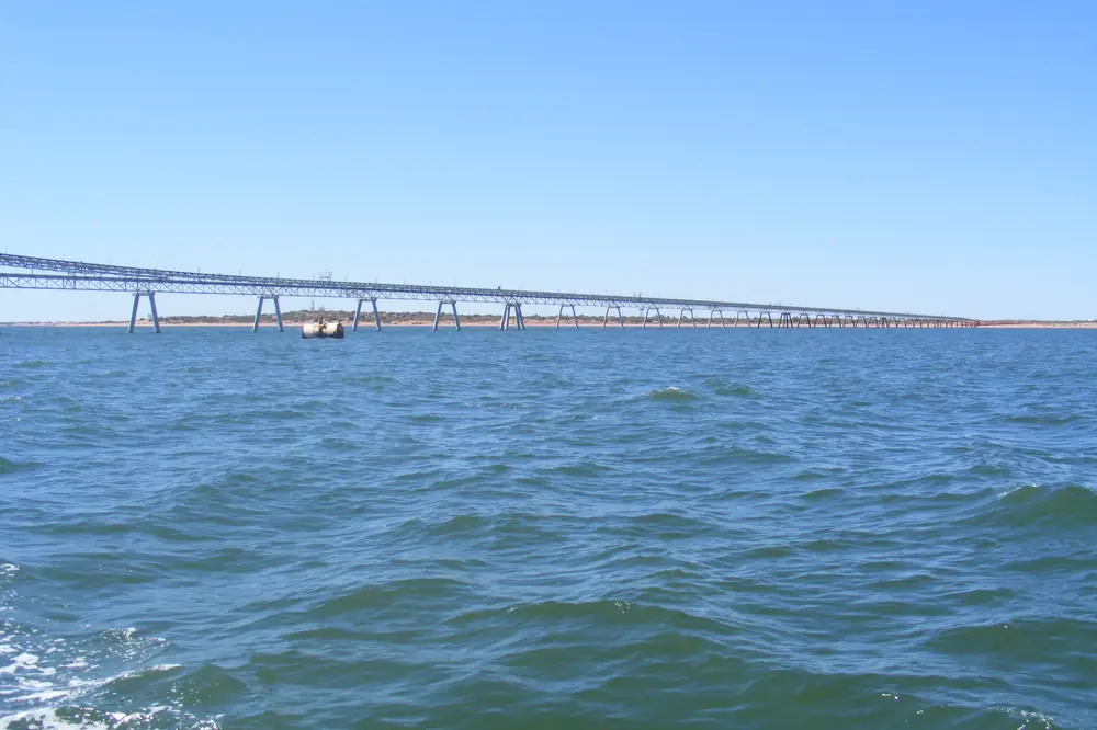
Onslow salt jetty stretching over the waterPhoto: Rob McGregor · CC BY 3.0 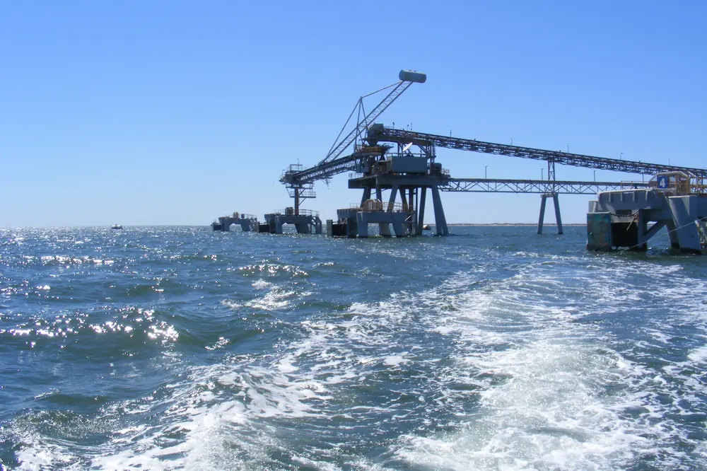
Head of the Onslow salt jettyPhoto: Rob McGregor · CC BY 3.0 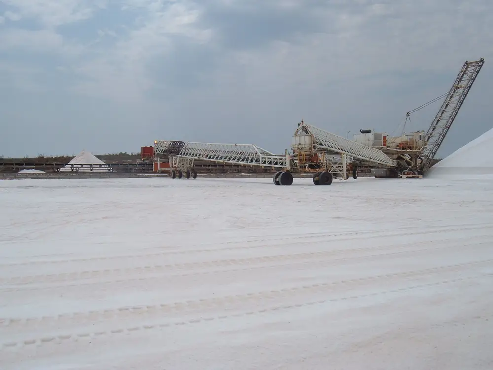
Salt harvester at OnslowPhoto: Rob McGregor · CC BY 3.0 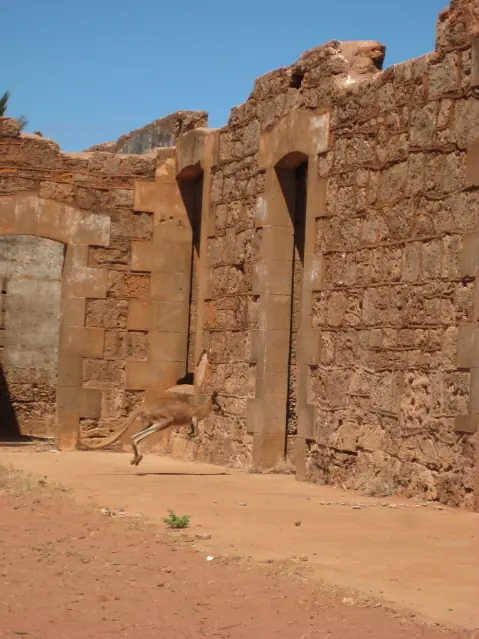
Kangaroo at Old Onslow stone ruinsPhoto: Calistemon · CC BY-SA 3.0
Onslow sits on the Pilbara coast in the Shire of Ashburton, at Beadon Creek, in Western Australia’s north-west. Visit Ashburton’s destination page puts it 470 km from Tom Price and 400 km from Exmouth. Australia’s North West puts Karratha 307 kilometres and Exmouth 400 kilometres via the North West Coastal Highway. This hub is the Ashburton coast town, not Exmouth and not a Ningaloo town page. Neighbour town pages on this site: Exmouth, Carnarvon and Karratha.
Visit Ashburton: Onslow was founded in 1885 at the mouth of the Ashburton River as a hub for exporting sheep, wool and pearl shell, then relocated 18 kilometres up the coast in 1925 to the present site near Beadon Creek. The 2021 Census counted 813 people in the urban centre. Travellers stop for Old Onslow, the Goods Shed Museum, salt ponds, fishing, and the Mackerel Islands. You still need Main Roads WA after rain or a cyclone watch, because a coastal highway run is no use if the road is closed.
Where it is, and how far
Onslow is the western Ashburton settlement off the North West Coastal Highway. Tourism WA: a three-hour drive from Karratha and four hours from Exmouth, and a side trip if you are following the Warlu Way — an interpretive 2,480-kilometre self-drive trail on that destination page. The Shire’s History and Heritage page prints the Warlu Way as nearly 2,500 km. Those are different official figures; this hub does not average them.
Official Perth kilometres do not agree. Print the discrepancy.
| Place | Distance from Onslow (sourced) |
|---|---|
| Perth | Visit Ashburton destination-guide Onslow table: 1,377 km. Tourism WA Old Onslow: approximately 1,500 km north. Tourism WA Onslow Beach Resort: 1,400 km drive / two-hour flight |
| Tom Price | Visit Ashburton destination page: 470 km. Destination-guide Onslow table: 471 km via Paraburdoo; 408 km via 48 km unsealed |
| Exmouth | Visit Ashburton and Australia’s North West: 400 km. Destination-guide table: 402 km. Town page: Exmouth |
| Karratha | Australia’s North West: 307 km. Destination-guide table: 311 km via North West Coastal Highway. Town page: Karratha |
| Paraburdoo | Destination-guide Onslow table: 391 km via Nanutarra–Munjina Road. Paraburdoo’s own table in that guide prints 387 km. Print both |
| Karijini National Park | Australia’s North West: 453 km via the Nanutarra/Munjina sealed road |
| Old Onslow | 18 km (Visit Ashburton Old Onslow page and destination pages) |
| Wheatstone | 12 km west, near Old Onslow (Visit Ashburton attractions) |
Do not add an Onslow–Carnarvon kilometre that was not on those sourced Onslow pages. Carnarvon is the Gascoyne service town further south.
Facts at a glance
Population. Australian Bureau of Statistics 2021 Census, Urban Centres and Localities UCL521040, Onslow (L): 813 people. Median age 35. Sex split 50.0% male / 50.0%. Families 193. Private dwellings 725. Average household size 2.5. Median weekly household income $2,596. Use the ABS UCL QuickStats page. Suburbs and Localities SAL51181 counted 829 people. Do not mix the two.
Climate. Bureau of Meteorology ONSLOW AIRPORT, 005017, 21.67°S, 115.11°E, elevation 11 m, commenced 1940, status: open, latest available data 14 November 2026. Mean maximum (61 years, 1943–2026): January 36.5 °C, July 25.7 °C, annual 32.2 °C. Mean minimum (60 years, 1943–2026): February 25.2 °C, July 13.1 °C, annual 19.3 °C. Mean rainfall (60 years, 1940–2026): annual 299.7 mm; March 68.4 mm wettest mean month; October 0.7 mm driest. Mean days of rain ≥ 1 mm: 16.9. The all-years table’s highest temperature is 50.7 °C on 13 January 2022. See Onslow weather.
Visitor information. Onslow Visitor Centre and Goods Shed Museum, 52 Second Avenue (attractions page) / Second Avenue on the visitor-centres page, (08) 9184 6644, onslowtc@bigpond.com. Official hours disagree: the visitor-centres page prints season open 1 April to 31 October, daily 10am till 3pm, closed public holidays, season close mid-December to 31 March; the destination guide prints 1 April to mid-November, daily 10am till 3pm; the Goods Shed page prints every day 9:00am–1:00pm, closed public holidays. Entry $3 cash only on the Goods Shed page. Confirm before you arrive. Tom Price Visitor Centre remains (08) 9188 5488 for inland park questions.
Traditional Owners
The Shire of Ashburton History and Heritage page names the Thalanyji People in the Onslow region. The 2021/22 Annual Report repeats Onslow: Thalanyji. Visit Ashburton’s destination guide: Wanthaya: Hello and Welcome to Thalanyji Country. The same guide names the Ashburton River Mindarru, the traditional Indigenous name given by the Thalanyji People, and records that the Wanamankurra created the rivers and still lives in the freshwater pools at Ten Mile and Five Mile Pools. The site for Old Onslow was chosen because of an Aboriginal freshwater soak or well.
Visit as a guest; see visiting Country respectfully. This guide does not flatten a Karijini Banyjima acknowledgement onto Beadon Creek.
History
Visit Ashburton, Australia’s North West and Tourism WA are the sources for this summary.
The original townsite was gazetted in October 1885 and named after Sir Alexander Onslow, Chief Justice of Western Australia. It supported stations along the Ashburton River. Minderoo, established in 1882, stands as one of the earliest recorded pastoral stations on the destination guide. Pearls were found in Exmouth Gulf and Onslow became the home port for a fleet of pearling luggers until the Second World War. Cyclones and silting of the Ashburton River wrecked the old port. By 1923 the decision was made to relocate; on 10 January 1924 the town of Beadon was gazetted and shortly thereafter renamed Onslow. In 1925 the old town, its buildings and inhabitants were moved about 18 kilometres up the coast by camel and donkey-drawn wagons. The Goods Shed was dismantled and transported by camel train to Beadon Point.
The destination guide notes 2025 as 100 years since that relocation. Remains at Old Onslow include the stone gaol, courthouse, police station and police quarters, and a refurbished cemetery. Tourism WA also names the post office, hospital and magistrates’ home among the stone buildings. The Goods Shed in today’s town displays railway rolling stock including a 1928 petrol locomotive from the Onslow tramway, cyclone history, and the bomb that fell on Onslow during WWII.
Salt and gas. Visit Ashburton: salt evaporation ponds cover 87 square kilometres as you drive into town (the Onslow Salt attraction page also prints over 90 km² and about 2.5 million tonnes of sodium chloride a year). The salt jetty extends nearly 1.3 kilometres at Sunset Beach. The Chevron Wheatstone Project is 12 kilometres west of Onslow, near Old Onslow — guided tour only, booked at the Visitor Centre.
Things to do
Visit Ashburton and Tourism WA name these in and around Onslow:
- Old Onslow Heritage Trail — 18 km; maps from the Visitor Centre; stone ruins at the Ashburton mouth
- Goods Shed Museum / Visitor Centre — Second Avenue; $3 cash; 1928 locomotive; WWII bomb exhibit
- ANZAC Memorial Park and Ian Blair Memorial Boardwalk (1 km) — Memorial Park to Sunset Beach
- Sunrise Beach and Sunset Beach — Tourism WA Staircase to the Moon at Sunrise Beach, full moon March to October
- Onslow Salt lookout on Back Beach Road, halfway to 4 Mile Creek; jetty at Sunset Beach
- Jerome Davenport murals on the town water tanks, 2023
- Fishing and crabbing — Sunrise and Sunset beaches, Four Mile Creek, Ashburton River, Beadon Creek; Three Mile and Five Mile pools
- Mackerel Islands — Tourism WA: 22 kilometres off the coast, group of 10 islands. Visit Ashburton: 12 nautical miles; ferry to Thevenard Island 45 minutes
- Hidden Treasures and Wheatstone bus tours in season, booked at the Visitor Centre
Nearby, not in-town: Karijini National Park is 453 km inland on Australia’s North West. Tom Price and Paraburdoo are the iron-ore neighbours on this site. See things to do in Onslow.
Where to stay
Visit Ashburton’s Onslow accommodation index names Ocean View Caravan Park, Onslow Beach Resort, Discovery Parks — Beadon Creek, Beadon Bay Hotel, Mackerel Islands @ Thevenard, and Peedamulla Campground. Tourism WA names camping and caravan parks, chalets, hotel and motel-style accommodation. Those are official named types, not a ranked strip.
- How to choose: Onslow accommodation
- Camping detail: Onslow caravan parks
- Operator enquiries: feature your business
Caravan and camping
Vans use Onslow as a coastal night off the North West Coastal Highway. Official named camping starts with Ocean View Caravan Park on Second Avenue / the foreshore. Discovery Parks — Beadon Creek and Peedamulla Campground are named on the same index. Tourism WA also names Three Mile Pool and Five Mile Pool as mud-crabbing and camping-under-the-stars spots — confirm current rules at the Visitor Centre before you treat a pool as a free camp. Read Onslow caravan parks and outback camping.
A 9 April 2026 Visit Ashburton news note said Ocean View would reopen from 13 April 2026, with one amenity block and the cabins unavailable after damage. Check current status. Do not camp among the Old Onslow ruins.
Fuel and services
A town of 813 people is large enough for fuel, a supermarket named as a five-minute walk from Ocean View, Onslow Health Service with a 24/7 emergency department on the WA Country Health Service Pilbara hospitals page, and a seasonal visitor centre. This guide does not list a bowser brand or invent clinic hours. Fill here if you are heading toward Nanutarra or back to the highway.
Aquatic Centre open September to May and Spray Park year-round on Visit Ashburton. Boat ramps named at Beadon Creek Community Boat Precinct, Sunrise Beach, 4 Mile Creek and Old Onslow.
For maps, use the Goods Shed. Roads: Main Roads WA. Cyclone watches are a BOM problem on this coast.
Road access
Access is via the North West Coastal Highway, then the Onslow Road. Australia’s North West and Visit Ashburton treat the Karratha and Exmouth approaches as the ordinary sealed run. Karijini is the Nanutarra/Munjina sealed road inland, 453 km on Australia’s North West. Visit Ashburton airports: Onslow Airport, direct from Perth in 2 hours; Australia’s North West names Virgin Australia daily direct flights.
These are freight, resource and tourist roads. Road trains, fatigue, wildlife and cyclones are the hazards. After rain or a cyclone warning, check Main Roads. Do not drive around closed signs to keep a beach sunset.
Nearby parks and towns
Named nature on official pages:
- Mackerel Islands / Thevenard Island — offshore; ferry and boat, not a town street
- Old Onslow and the Ashburton River — 18 km
- Karijini National Park — 453 km inland
Towns on this site:
- Tom Price — 470 km inland on Visit Ashburton
- Paraburdoo — 387–391 km on the destination-guide tables
- Newman — East Pilbara neighbour on this site
- Pannawonica — Shire of Ashburton closed mining town, 200–204 km on Visit Ashburton
- Exmouth — North West Cape, 400 km on Visit Ashburton
- Karratha — 307 km on Australia’s North West
- Carnarvon — Gascoyne service town further south
When to go, and how long
Visit Ashburton peak season April to September. BOM Onslow Airport’s January mean maximum of 36.5 °C is milder than Paraburdoo Aero’s 40.8 °C, still a sun-and-cyclone problem. July’s 25.7 °C mean maximum and 13.1 °C mean minimum, with October’s 0.7 mm, is the dry, cooler coast on a 299.7 mm annual table. Tourism WA’s Staircase to the Moon window is full moon March to October at Sunrise Beach.
An hour covers the Goods Shed if it is in season and a beach walk. A half day adds Old Onslow. A night covers fuel and a named room or van site. The Mackerel Islands are a separate boat day, not a town walk.
Operators who want a checked listing: feature your business. The listings slot on this hub stays empty until then.
Plan this trip
Tell us the dates, who you are travelling with and where you need help. We reply with planning notes for Onslow — we are not a booking agent.
Events and road-conditions newsletter
Occasional notes on outback festivals, race days and official road-condition sources — not a daily blast. We use these details only to send the newsletter.
Western Australia · North West
Onslow accommodation
Where to stay in Onslow: Visit Ashburton names Onslow Beach Resort, Beadon Bay Hotel, Ocean View Caravan Park, Discovery Parks Beadon Creek and Peedamulla. Confirm before you unhitch. Not Exmouth.
Read · 4 min
Western Australia · North West
Onslow caravan parks
Camping in Onslow: Visit Ashburton names Ocean View Caravan Park, Discovery Parks Beadon Creek and Peedamulla Campground. Confirm before you unhitch. Pilbara coast, not Exmouth.
Read · 3 min
Western Australia · North West
Onslow weather
Onslow climate from BOM Onslow Airport (005017): January mean max 36.5 °C, July 25.7 °C, annual rainfall 299.7 mm. Highest 50.7 °C on 13 January 2022. Pilbara coast, not Exmouth.
Read · 4 min
Western Australia · North West
Things to do in Onslow
Things to do in Onslow: Old Onslow ruins 18 km south, Goods Shed Museum, ANZAC park and boardwalk, salt jetty, Staircase to the Moon. Pilbara coast, not Exmouth / Ningaloo.
Read · 5 min
Frequently asked questions
Is Onslow the same as Exmouth or Ningaloo?
No. This hub is Onslow in the Shire of Ashburton, on the Pilbara coast at Beadon Creek. Visit Ashburton puts Exmouth 400 km away. Exmouth has a town page on this site; Ningaloo Marine Park does not — use Parks WA. Karijini is the inland park neighbour on this site, 453 km on Australia’s North West via the Nanutarra/Munjina sealed road.
How far is Onslow from Perth, Tom Price and Karratha?
Visit Ashburton’s destination-guide Onslow table puts Perth 1,377 km. Tourism WA’s Old Onslow listing prints approximately 1,500 kilometres north of Perth; the Onslow Beach Resort listing prints a 1,400 kilometre drive. Visit Ashburton’s Onslow destination page: 470 km from Tom Price and 400 km from Exmouth. Australia’s North West: Karratha 307 kilometres and Exmouth 400 kilometres. Tourism WA: a three-hour drive from Karratha and four hours from Exmouth. This hub prints the disagreement and does not pick a single Perth kilometre.
What is Onslow’s population?
813 people at the 2021 Census for the urban centre Onslow (L) (UCL521040), median age 35. The suburbs-and-localities count is 829 (SAL51181). Do not mix the two.
Whose Country is Onslow on?
The Shire of Ashburton History and Heritage page and the 2021/22 Annual Report name the Thalanyji People in the Onslow region. Visit Ashburton’s destination guide opens Old Onslow with Wanthaya: hello and welcome to Thalanyji Country, and names the Ashburton River Mindarru.
What is the weather like in Onslow?
BOM Onslow Airport (005017, open): January mean maximum 36.5 °C, July 25.7 °C, annual rainfall 299.7 mm. March is the wettest mean month at 68.4 mm; October the driest at 0.7 mm. The all-years table’s highest temperature is 50.7 °C on 13 January 2022.
Can I camp in Onslow?
Yes, as named types. Visit Ashburton names Ocean View Caravan Park (powered and unpowered sites and self-contained cabins), Discovery Parks — Beadon Creek, and Peedamulla Campground between the North West Coastal Highway and Onslow Road. Tourism WA names camping and caravan parks, chalets, hotel and motel-style accommodation. Confirm on arrival. A 9 April 2026 Visit Ashburton news note said one amenity block and the cabins at Ocean View were unavailable after damage — check current status.
Sources and further reading
Facts on this page were checked against these primary and official sources. Conditions change — confirm before you travel or buy.
- Onslow (L) 2021 Census QuickStats (UCL521040) — Australian Bureau of Statistics
- Onslow 2021 Census QuickStats (SAL51181) — Australian Bureau of Statistics
- Climate statistics for Onslow Airport (005017) — Bureau of Meteorology
- Onslow — Shire of Ashburton (Visit Ashburton)
- Onslow — Attractions — Shire of Ashburton (Visit Ashburton)
- Old Onslow Historic Townsite — Shire of Ashburton (Visit Ashburton)
- Onslow Visitor Centre and Goods Shed Museum — Shire of Ashburton (Visit Ashburton)
- Visit Ashburton destination guide — Shire of Ashburton (Visit Ashburton)
- Onslow — Australia's North West
- Onslow — Tourism Western Australia
- Old Onslow Historic Townsite — Tourism Western Australia
- History and Heritage — Shire of Ashburton
- Pilbara hospitals and health services — WA Country Health Service
- Main Roads WA travel map — Main Roads Western Australia