At a glance
Sourced facts only. Distances and services change — confirm before you travel.
- Local government
- City of Karratha
- Traditional Owners
- Ngarluma people, place name Yirramagardu (City of Karratha Roebourne Heritage Trail). City of Karratha Roebourne Structure Plan also names Yindjibarndi Ieramugado and notes the townsite sits within the Ngarluma Determination Area granted in 2005 in favour of the Ngarluma and Yindjibarndi.Confirm current wording at the Roebourne Visitor Centre / Ganalili Centre.
- Capital
- Trails WA Roebourne Heritage Trail: 1,500 km from Perth.
- Nearest fuel
- City of Karratha Roebourne Structure Plan names a BP service station among the Roe Street / North West Coastal Highway commercial strip. Confirm the bowser on arrival.
- Nearest hospital or clinic
- Roebourne Hospital (WA Country Health Service Pilbara hospitals page), 24/7 emergency department and telehealth. Healthdirect: 42–44 Hampton Street, (08) 9182 0200.
- Mobile coverage
- Check Telstra and Optus coverage maps before travel; do not assume a signal on the Heritage Trail outer sites or the Roebourne–Wittenoom Road toward Millstream.
- Best time to visit
- Trails WA Heritage Trail: June to September. Tourism WA Millstream: May–August. BOM Roebourne Aero June mean maximum 27.9 °C; December 39.7 °C.
Climate
Monthly means from the Bureau of Meteorology station Roebourne Aero (004090). This is not a forecast. Open airfield table 2.3 km from closed Roebourne (004035), which closed 13 September 2021. Do not blend the two stations. Temperature maxima 25 years (2001–2026); minima 24 years; rainfall 21 years (2001–2026). Latest available data 14 November 2026. Summer-peak rain (January 62.6 mm).
| Month | Mean max (°C) | Mean min (°C) | Rainfall (mm) |
|---|---|---|---|
| Jan | 38.9 | 26.5 | 62.6 |
| Feb | 38.4 | 26.4 | 55.5 |
| Mar | 37.9 | 25.5 | 44.2 |
| Apr | 36.2 | 21.9 | 8.7 |
| May | 31.6 | 16.8 | 35.9 |
| Jun | 27.9 | 13.8 | 29.2 |
| Jul | 28.1 | 12.1 | 8.8 |
| Aug | 30.5 | 12.9 | 2.0 |
| Sep | 33.8 | 15.9 | 2.8 |
| Oct | 37.5 | 19.7 | 1.1 |
| Nov | 38.6 | 22.4 | 1.8 |
| Dec | 39.7 | 25.1 | 13.6 |
Roebourne in pictures
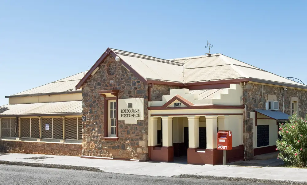
Roebourne Post OfficePhoto: Michal Lewi · CC BY-SA 4.0 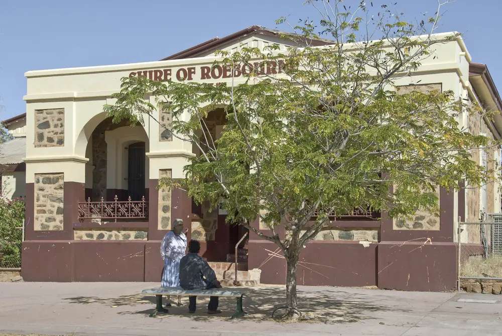
Former Roebourne Shire OfficesPhoto: Michal Lewi · CC BY-SA 4.0 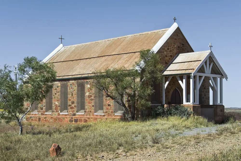
Holy Trinity Church in RoebournePhoto: Michal Lewi · CC BY-SA 4.0 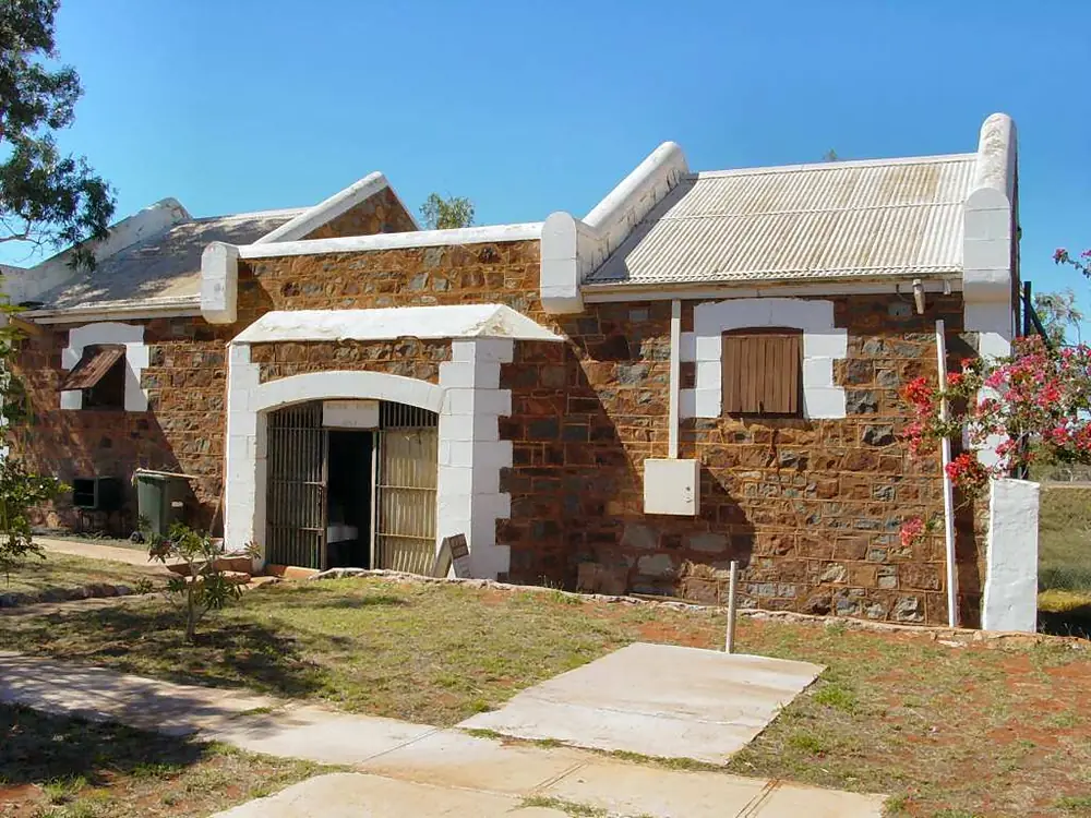
Roebourne tourist centrePhoto: Yewenyi · CC BY-SA 3.0
Roebourne sits on the North West Coastal Highway and the Harding River in Western Australia’s North West, inside the City of Karratha. Trails WA: the oldest town between Geraldton and Darwin, 1,500 km from Perth. City of Karratha: gazetted in 1866, the first town in the North West of Western Australia. Tourism WA’s Old Gaol listing: a half-hour drive east of Karratha. The City Structure Plan: approximately 40 km east of Karratha. This hub is that heritage river town — not a Karratha suburb, not Port Hedland, not Dampier and not Wickham. Those neighbours now have town pages on this site. Geraldton and Darwin have no town pages here — named, not linked. Perth is the capital; it has no town page here.
Trails WA’s restored-stone sentence is the hinge used here: once the administrative centre of the North West, its restored heritage stone buildings speak to its earlier prosperity and include some designed by renowned Public Works Department Architect George Temple Poole. That is an 1866 administrative-and-gaol story, not an iron-ore closed-town reprint of Pannawonica and not a Karijini gateway reprint of Tom Price.
The ABS publishes two 2021 geographies. Use urban centre Roebourne (L) UCL521046: 700 people, median age 34, sex split 49.6% male / 50.4% female, Aboriginal and/or Torres Strait Islander people 477 (68.1%). 170 families, 297 private dwellings, average household 2.9. Suburbs-and-localities SAL51305 counted 975, median age 34, Indigenous 717 (73.5%), 187 families, 319 dwellings. Do not mix them. Do not use a larger SA2 figure that includes other localities. Travellers stop for the Heritage Trail, the Old Gaol and a highway night. You still need Main Roads WA after rain.
Where it is, and how far
Roebourne is the North West Coastal Highway town on the Harding River, east of Karratha on Tourism WA and the City Structure Plan. Perth to Darwin via the Pilbara is the long corridor. Cossack, Wickham and Point Samson sit on the Emma Withnell / Point Samson–Roebourne geometry named in City and tourism pages.
Official Karratha measures do not agree as a single number. Print both.
| Place | Distance from Roebourne (sourced) |
|---|---|
| Perth | 1,500 km (Trails WA Heritage Trail) |
| Karratha | Half-hour drive east of Karratha (Tourism WA Old Gaol). Approximately 40 km east of Karratha (City Structure Plan). Visit Ashburton Millstream table: Roebourne to Karratha 39 km |
| Millstream Chichester | 1.5-hour drive (Tourism WA Millstream). Visit Ashburton Millstream table: Roebourne via Roebourne–Wittenoom Road 122 km |
| Heritage Trail outer sites / parking bay | 2.5 km along the North West Coastal Highway from the trail start (City Heritage Trail brochure) |
| Trail start | Roebourne Police Station, Gaol and Court Precinct (Trails WA) |
A Roebourne–Marble Bar or Roebourne–Onslow kilometre was not on those sourced town pages, so this hub does not invent one.
Facts at a glance
Population. ABS 2021 Census Urban Centres UCL521046: 700 people. Median age 34. Use the UCL QuickStats. SAL SAL51305: 975 people. Do not mix.
Climate. Bureau of Meteorology ROEBOURNE AERO, 004090, 20.76°S, 117.16°E, elevation 11 m, commenced 2001, status: open, latest available data 14 November 2026. This is the open table 2.3 km from closed ROEBOURNE 004035 (closed 13 September 2021). Mean maximum (25 years, 2001–2026): December 39.7 °C, June 27.9 °C, annual 34.9 °C. Mean minimum (24 years): January 26.5 °C, July 12.1 °C, annual 19.9 °C. Mean rainfall (21 years, 2001–2026): annual 274.8 mm; January 62.6 mm wettest mean month; October 1.1 mm driest. Do not blend 004035 into these YAML months. See Roebourne weather.
Visitor information. Official pages disagree on the desk, so this hub prints them. Tourism WA Old Gaol: the Roebourne Visitor Centre is no longer located at the Old Gaol; more information at the information bay heading towards Karratha, or at the Karratha Tourism Information Centre. Trails WA: Roebourne Visitor Centre, 34 Roe Street, (08) 9144 4600. Western Australian Museum WAnderland: Ganalili Centre in the old Victoria Hotel, 38 Roe Street, doubling as the Roebourne Visitor Centre. Confirm which door is actually open. Roads: Main Roads WA.
Traditional Owners
City of Karratha Heritage Trail: the Ngarluma people are the traditional owners of this land and call this place Yirramagardu. The City Structure Plan: the townsite sits within the Ngarluma Determination Area granted in 2005 in favour of the Ngarluma and Yindjibarndi; Aboriginal names Yirramagardu (Ngarluma) and Ieramugado (Yindjibarndi). The Structure Plan: Roebourne is a hub for Aboriginal enterprise and culture and is home to the Ngarluma people, as well as many Yindjibarndi and Banyjima people from outlying stations. Western Australian Museum: Ganalili is the Yindjibarndi word for the light in the morning before the rising of the sun; Juluwarlu is the public face for Yindjibarndi artists. Confirm current wording at Ganalili / the visitor centre. See visiting Country respectfully.
History
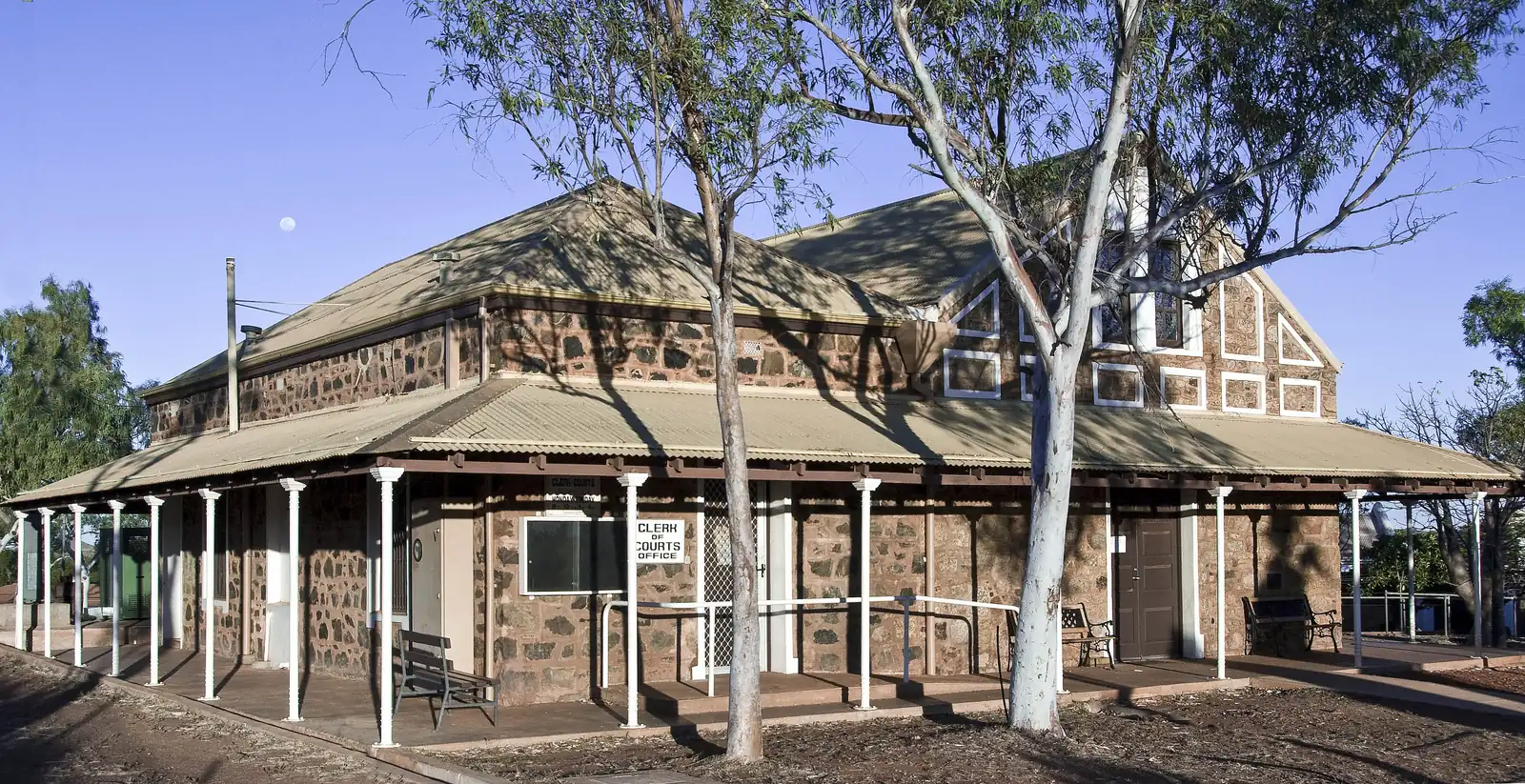
City of Karratha: gazetted in 1866, first town in the North West. Trails WA: named after the first Western Australian surveyor, General John Septimus Roe. Once the administrative centre of the North West. Tourism WA Old Gaol: the large octagon-shaped building contains four wings, each of which houses up to 40 prisoners; built with local stone quarried with the assistance of Aboriginal labour; a harsh reminder of the colonial past. Visit Roebourne’s other historic buildings: Holy Trinity Church, Union Bank, Victoria Hotel, Post Office, Hospital and the Court House.
This is an 1866 administrative town with a gaol overlay, not a 1970 closed mining town. For the park pools, use Millstream Chichester National Park rather than treating Roe Street as a gorge walk.
Things to do
City of Karratha, Trails WA and Tourism WA name these in and around Roebourne:
- Roebourne Heritage Trail — City: self-guided 5 km walk or drive, extended 8 km to three outer-town sites; 18 buildings and sites. Trails WA: 8 km, 1–3 hours, start at the Police Station / Gaol / Court precinct; June to September
- Old Gaol Museum — Tourism WA; octagon; four wings
- Holy Trinity Church, Union Bank, Victoria Hotel, Post Office, Hospital, Court House — Tourism WA Old Gaol listing
- Ganalili Centre / Juluwarlu — WA Museum: café, gallery, Yindjibarndi exhibitions; 38 Roe Street
- Harding River — Structure Plan conservation and recreation around the river; caravan park named beside it
Nearby, not in-town: Millstream Chichester National Park is a 1.5-hour drive on Tourism WA. Cossack, Wickham and Point Samson are named on City and tourism pages. Karijini National Park is a Tom Price / Paraburdoo day, not a Roebourne footpath.
See things to do in Roebourne.
Where to stay
The City of Karratha camping brochure names Harding River Caravan Park, Mundumia Way, 9182 1063. The Structure Plan also names that park. Tourism WA Old Gaol names the Victoria Hotel as a historic building, not as a 2026 room inventory this hub will invent. WA Museum: Ganalili occupies the old Victoria Hotel as a cultural centre. Those are official named types. This hub does not reprint dollar figures that date. If Roebourne is full, Karratha stays named in the City brochure (Balmoral, Karratha Caravan Park, Pilbara Holiday Park).
- How to choose: Roebourne accommodation
- Camping detail: Roebourne caravan parks
- Operator enquiries: feature your business
Caravan and camping
Vans use Roebourne as a North West Coastal Highway night between the coast and Millstream. Official named camping in town is Harding River Caravan Park. The City camping brochure also lists Cossack Budget Accommodation, Dampier Transit Park, Point Samson parks — see Cossack, Dampier and Point Samson. Ask on arrival for stay limits. Read Roebourne caravan parks and outback camping. Do not camp on the Heritage Trail or treat Harding River picnic tables as a free camp.
Fuel and services
The City Structure Plan names a BP service station on the Roe Street / North West Coastal Highway strip, plus a post office, general store, library (Padbury and Sholl Streets), hospital, swimming pool and recreation hall. WACHS: Roebourne Hospital, 24/7 emergency department and telehealth. Healthdirect: 42–44 Hampton Street, (08) 9182 0200. Confirm the bowser is actually open; a structure-plan pin is not 2026 hours.
Karratha Health Campus sits in Karratha — not this town’s hospital. For maps use Ganalili / the visitor centre or the Karratha Tourism Information Centre Tourism WA names. Roads: Main Roads WA.
Road access
The North West Coastal Highway is sealed. Trails WA: Heritage Trail access is 2WD. Tourism WA Millstream: 1.5 hours from Roebourne. Australia’s North West Millstream page: if travelling the Roebourne–Wittenoom Road, the turnoff is 28 kilometres south-east of Roebourne. After rain, that unsealed park approach is the constraint. Main Roads first.
West: Karratha, Dampier. East: Port Hedland. Inland: Marble Bar is the East Pilbara neighbour on this site. Onslow is the Ashburton coast. Tom Price is the Karijini gateway. Pannawonica is the closed Robe River town. Perth to Darwin via the Pilbara is the long corridor.
Nearby parks and towns
Named nature on official pages:
- Harding River corridor — Structure Plan conservation and recreation
- Millstream Chichester National Park — 1.5 hours / 122 km on official pages
- Karijini National Park — inland from Tom Price, not a Roebourne walk
Towns on this site:
- Marble Bar — East Pilbara neighbour
- Tom Price — Karijini gateway
- Onslow — Ashburton coast
- Pannawonica — Shire of Ashburton closed mining town
- Newman — East Pilbara iron-ore neighbour
- Paraburdoo — southern Ashburton iron-ore town
- Karratha — City of Karratha seat, half-hour west on Tourism WA
- Port Hedland — Town of Port Hedland harbour city
- Dampier — port town 20 km west of Karratha on Australia’s North West
- Wickham — City of Karratha town on the Roebourne–Point Samson Road
- Point Samson — fishing hamlet, 20 minutes north on Tourism WA
- Cossack — historic townsite, 20 minutes north on Tourism WA
Geraldton and Darwin have no town pages here — named, not linked.
When to go, and how long
Trails WA Heritage Trail: June to September. Tourism WA Millstream: May–August. BOM Roebourne Aero’s December mean maximum of 39.7 °C is hot Pilbara summer. June’s 27.9 °C mean maximum is the coolest mean-max month on that open table — cooler than July’s 28.1 °C. January’s 62.6 mm is the wettest mean month on a 274.8 mm annual table.
An hour covers the Old Gaol if it is open and a Heritage Trail photograph. A half day adds the 5 km City walk in cooler hours. A night covers fuel and a named van site. Millstream is a separate park day. Cossack is a named coastal hour, not a Roebourne suburb.
Operators who want a checked listing: feature your business. The listings slot on this hub stays empty until then.
Plan this trip
Tell us the dates, who you are travelling with and where you need help. We reply with planning notes for Roebourne — we are not a booking agent.
Events and road-conditions newsletter
Occasional notes on outback festivals, race days and official road-condition sources — not a daily blast. We use these details only to send the newsletter.
Western Australia · North West
Roebourne accommodation
Where to stay in Roebourne: the City of Karratha names Harding River Caravan Park on Mundumia Way. Confirm before you unhitch. This is Roebourne, not a Karratha hotel strip.
Read · 3 min
Western Australia · North West
Roebourne caravan parks
Camping in Roebourne: the City of Karratha names Harding River Caravan Park on Mundumia Way. Heritage Trail picnic tables are not a free camp. Confirm before you unhitch.
Read · 3 min
Western Australia · North West
Roebourne weather
Roebourne climate from open BOM Roebourne Aero (004090): December mean max 39.7 °C, June 27.9 °C, annual rainfall 274.8 mm with January 62.6 mm. Closed town station 004035 is not blended.
Read · 4 min
Western Australia · North West
Things to do in Roebourne
Things to do in Roebourne: Heritage Trail 5–8 km, Old Gaol Museum, Ganalili Centre. Millstream is a 1.5-hour park day. This is Roebourne, not Karratha, Port Hedland, Dampier or Wickham.
Read · 4 min
Frequently asked questions
Is Roebourne the same as Karratha or Port Hedland?
No. This hub is Roebourne in the City of Karratha, Western Australia, on the North West Coastal Highway and the Harding River. Trails WA: the oldest town between Geraldton and Darwin. Tourism WA’s Old Gaol listing: a half-hour drive east of Karratha. Karratha, Port Hedland, Dampier and Wickham now have town pages on this site.
How far is Roebourne from Perth, Karratha and Millstream?
Trails WA: 1,500 km from Perth. Tourism WA Old Gaol: half-hour drive east of Karratha. City of Karratha Structure Plan: approximately 40 km east of Karratha. Tourism WA Millstream Chichester: a 1.5-hour drive from Roebourne. Visit Ashburton’s Millstream distances table: Roebourne (via Roebourne–Wittenoom Road) 122 km from Millstream.
What is Roebourne’s population?
Use the 2021 urban centre Roebourne (L) UCL521046: 700 people, median age 34, Aboriginal and/or Torres Strait Islander people 477 (68.1%). Suburbs-and-localities SAL51305 counted 975, median age 34, Indigenous 717 (73.5%). Do not mix the two geographies. Do not use a larger SA2 figure that includes other localities.
What is there to do in Roebourne?
City of Karratha and Trails WA name the Roebourne Heritage Trail: a self-guided 5 km walk or drive, with an extended 8 km option to three outer-town sites, covering 18 historic sites. Tourism WA names the Old Gaol Museum and other historic buildings including Holy Trinity Church, Union Bank, Victoria Hotel, Post Office, Hospital and the Court House. Tourism WA Millstream Chichester is a 1.5-hour drive. Cossack and Point Samson are named gateways — they now have town pages on this site.
What is the weather like in Roebourne?
BOM Roebourne (004035) closed on 13 September 2021. This hub uses the nearest complete open table, Roebourne Aero (004090, 2.3 km): December mean maximum 39.7 °C, June 27.9 °C, annual rainfall 274.8 mm (21 years, 2001–2026). January is the wettest mean month at 62.6 mm. Do not blend the two stations.
Can I camp at Roebourne?
Yes, as named types. The City of Karratha camping brochure names Harding River Caravan Park, Mundumia Way, Roebourne, 9182 1063. The City Structure Plan also names Harding River Caravan Park. Trails WA names cafe, car park, picnic area and public toilet among trail facilities — those are day facilities, not a second park. Confirm on arrival.
Sources and further reading
Facts on this page were checked against these primary and official sources. Conditions change — confirm before you travel or buy.
- Roebourne (L) 2021 Census QuickStats (UCL521046) — Australian Bureau of Statistics
- Roebourne 2021 Census QuickStats (SAL51305) — Australian Bureau of Statistics
- Climate statistics for Roebourne Aero (004090) — Bureau of Meteorology
- Climate statistics for Roebourne (004035) — Bureau of Meteorology
- Roebourne Heritage Trail — City of Karratha
- Roebourne Heritage Trail — Trails WA
- Roebourne Heritage Trail — Tourism Western Australia
- Roebourne Old Gaol Museum — Tourism Western Australia
- Millstream Chichester National Park — Tourism Western Australia
- Camping in the City of Karratha — City of Karratha
- Roebourne Structure Plan Part B — City of Karratha
- Pilbara Hospitals and Health Services — WA Country Health Service
- Ganalili Centre and Juluwarlu Aboriginal Corporation — Western Australian Museum
- Visit Ashburton destination guide — Visit Ashburton
- Main Roads WA travel map — Main Roads Western Australia